Huchenneville geodata
Huchenneville (Hauts-de-France) is a populated place; located in France in Europe/Paris (GMT+2) time zone. With population of 678 people, there are 12092 cities with bigger population in this country. Compared to other cities in France, 93.9% of cities are located further ↓South; 59.4% of cities are located further →East and 71% of cities have higher elevation than Huchenneville. Note1
Administrative division(s):
- Level 1: Hauts-de-France
- Level 2: Somme
- Level 3: Abbeville
- Level 4: Huchenneville


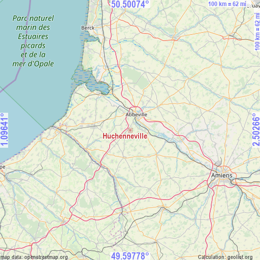
Huchenneville GPS coordinates[2]
50° 3' 4.968" North, 1° 47' 58.344" East
| Map corner | latitude | longitude |
|---|---|---|
| Upper-left | 50.50074°, | 1.09641° |
| Center: | 50.05138°, | 1.79954° |
| Lower-right: | 49.59778°, | 2.50266° |
| Map W x H: | 100.4×100.4 km | = 62.4×62.4mi |
| max Lat: | 51.07786° ⇑6.1% North |
| Huchenneville: | 50.05138° |
| min Lat: | ⇓93.9% South 41.3874° |
| min Long | Huchenneville | max Long |
| -5.08615° | 1.79954° | 9.52242° |
| W 40.6%⇐ | ⇒59.4% E |
Elevation
Elevation of Huchenneville is 76 m = 249 ft, and this is 117.7 m = 386 ft below average elevation for this country.
| Max E: |
2333 m = 7654 ft | 71% |
| Avg. | 193.7 m = 635 ft | |
| Huchenneville | 76 m = 249 ft | |
Min E: |
-1 m = -3 ft | 29% |
See also: France elevation on elevation.city.
Geographical zone
Huchenneville is located in North temperate zone (between Tropic of Cancer and the Arctic Circle). Distance of this North polar circle is 1836 km =1140.8 mi to North.| Distance of | km | miles | from Huchenneville |
|---|---|---|---|
| North Pole | 4441.9 | 2760.1 | to North |
| Arctic Circle | 1836 | 1140.8 | to North |
| Tropic Cancer | 2959.3 | 1838.8 | to South |
| Equator | 5565.2 | 3458.1 | to South |


Nearby cities:
15 places around Huchenneville: (largest is in red/bold)
• Abbeville
6.5 km =4 mi,  23°
23°
• Acheux-en-Vimeu
8.9 km =5.5 mi,  279°
279°
• Cambron
6.9 km =4.3 mi,  342°
342°
• Caours
10.7 km =6.6 mi,  35°
35°
• Hallencourt
8.6 km =5.3 mi,  140°
140°
• Huppy
3.9 km =2.4 mi,  221°
221°
• Mareuil-Caubert
2.9 km =1.8 mi,  49°
49°
• Miannay
7.7 km =4.8 mi,  311°
311°
• Moyenneville
4.1 km =2.5 mi,  301°
301°
• Oisemont
10.9 km =6.8 mi,  192°
192°
• Pont-Remy
8.4 km =5.2 mi,  91°
91°
• Quesnoy-le-Montant
10.3 km =6.4 mi, 309°
• Tours-en-Vimeu
8.4 km =5.2 mi,  257°
257°
• Vauchelles-les-Quesnoy
8.1 km =5 mi, 47°
• Épagne-Épagnette
5.7 km =3.5 mi,  66°
66°
Sources, notices
• [Note1] Compared only with cities in France existing in our database
• [Src1] Map data: © OpenStreetMap contributors (CC-BY-SA)
• [Src2] Other city data from geonames.org with taken over terms of usage.
• [Src3] Geographical zone / Annual Mean Temperature by Robert A. Rohde @ Wikipedia
