Cambes-en-Plaine geodata
Cambes-en-Plaine (Normandy) is a populated place; located in France in Europe/Paris (GMT+2) time zone. With population of 1,550 people, there are 6010 cities with bigger population in this country. Compared to other cities in France, 84.8% of cities are located further ↓South; 81.9% of cities are located further →East and 79% of cities have higher elevation than Cambes-en-Plaine. Note1
Administrative division(s):
- Level 1: Normandy
- Level 2: Calvados
- Level 3: Arrondissement de Caen
- Level 4: Cambes-en-Plaine


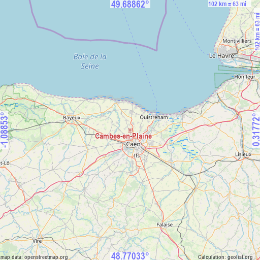
Cambes-en-Plaine GPS coordinates[2]
49° 13' 53.796" North, 0° 23' 7.44" West
| Map corner | latitude | longitude |
|---|---|---|
| Upper-left | 49.68862°, | -1.08853° |
| Center: | 49.23161°, | -0.3854° |
| Lower-right: | 48.77033°, | 0.31772° |
| Map W x H: | 102.1×102.1 km | = 63.4×63.4mi |
| max Lat: | 51.07786° ⇑15.2% North |
| Cambes-en-Plaine: | 49.23161° |
| min Lat: | ⇓84.8% South 41.3874° |
| min Long | Cambes-en-Plain | max Long |
| -5.08615° | -0.3854° | 9.52242° |
| W 18.1%⇐ | ⇒81.9% E |
Elevation
Elevation of Cambes-en-Plaine is 57 m = 187 ft, and this is 136.7 m = 448 ft below average elevation for this country.
| Max E: |
2333 m = 7654 ft | 79% |
| Avg. | 193.7 m = 635 ft | |
| Cambes-en-Plaine | 57 m = 187 ft | |
Min E: |
-1 m = -3 ft | 21% |
See also: France elevation on elevation.city.
Geographical zone
Cambes-en-Plaine is located in North temperate zone (between Tropic of Cancer and the Arctic Circle). Distance of this North polar circle is 1927.1 km =1197.4 mi to North.| Distance of | km | miles | from Cambes-en-Plaine |
|---|---|---|---|
| North Pole | 4533 | 2816.7 | to North |
| Arctic Circle | 1927.1 | 1197.4 | to North |
| Tropic Cancer | 2868.1 | 1782.2 | to South |
| Equator | 5474 | 3401.4 | to South |


Nearby cities:
15 places around Cambes-en-Plaine: (largest is in red/bold)
• Anguerny
4.1 km =2.5 mi,  343°
343°
• Anisy
2.2 km =1.4 mi,  348°
348°
• Authie
4.4 km =2.7 mi,  230°
230°
• Basly
5.9 km =3.7 mi,  332°
332°
• Beuville
4.5 km =2.8 mi,  72°
72°
• Biéville-Beuville
4.4 km =2.7 mi, 73°
• Caen
5.4 km =3.4 mi,  159°
159°
• Cairon
4.8 km =3 mi,  281°
281°
• Mathieu
2.7 km =1.7 mi,  21°
21°
• Rosel
5.3 km =3.3 mi,  266°
266°
• Saint-Contest
2.3 km =1.4 mi,  211°
211°
• Saint-Germain-la-Blanche-Herbe
5.5 km =3.4 mi,  194°
194°
• Thaon
5.9 km =3.7 mi,  299°
299°
• Villons-les-Buissons
2 km =1.2 mi, 299°
• Épron
1.5 km =0.9 mi,  136°
136°
Sources, notices
• [Note1] Compared only with cities in France existing in our database
• [Src1] Map data: © OpenStreetMap contributors (CC-BY-SA)
• [Src2] Other city data from geonames.org with taken over terms of usage.
• [Src3] Geographical zone / Annual Mean Temperature by Robert A. Rohde @ Wikipedia
