Chevilly-Larue geodata
Chevilly-Larue (Île-de-France) is a populated place; located in France in Europe/Paris (GMT+2) time zone. With population of 20,125 people, there are 453 cities with bigger population in this country. Compared to other cities in France, 74.7% of cities are located further ↓South; 51.8% of cities are located further →East and 65.3% of cities have higher elevation than Chevilly-Larue. Note1
Administrative division(s):
- Level 1: Île-de-France
- Level 2: Val-de-Marne
- Level 3: Arrondissement de L'Haÿ-les-Roses
- Level 4: Chevilly-Larue


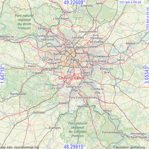
Chevilly-Larue GPS coordinates[2]
48° 45' 53.136" North, 2° 21' 1.08" East
| Map corner | latitude | longitude |
|---|---|---|
| Upper-left | 49.22609°, | 1.64718° |
| Center: | 48.76476°, | 2.3503° |
| Lower-right: | 48.29915°, | 3.05343° |
| Map W x H: | 103.1×103.1 km | = 64.1×64.1mi |
| max Lat: | 51.07786° ⇑25.3% North |
| Chevilly-Larue: | 48.76476° |
| min Lat: | ⇓74.7% South 41.3874° |
| min Long | Chevilly-Larue | max Long |
| -5.08615° | 2.3503° | 9.52242° |
| W 48.2%⇐ | ⇒51.8% E |
Elevation
Elevation of Chevilly-Larue is 89 m = 292 ft, and this is 104.7 m = 344 ft below average elevation for this country.
| Max E: |
2333 m = 7654 ft | 65.3% |
| Avg. | 193.7 m = 635 ft | |
| Chevilly-Larue | 89 m = 292 ft | |
Min E: |
-1 m = -3 ft | 34.7% |
See also: France elevation on elevation.city.
Geographical zone
Chevilly-Larue is located in North temperate zone (between Tropic of Cancer and the Arctic Circle). Distance of this North polar circle is 1979 km =1229.7 mi to North.| Distance of | km | miles | from Chevilly-Larue |
|---|---|---|---|
| North Pole | 4584.9 | 2848.9 | to North |
| Arctic Circle | 1979 | 1229.7 | to North |
| Tropic Cancer | 2816.2 | 1749.9 | to South |
| Equator | 5422.1 | 3369.1 | to South |


Nearby cities:
15 places around Chevilly-Larue: (largest is in red/bold)
• Antony
4.1 km =2.5 mi,  252°
252°
• Arcueil
4.1 km =2.5 mi,  341°
341°
• Bagneux
4.6 km =2.9 mi,  317°
317°
• Bourg-la-Reine
2.9 km =1.8 mi,  303°
303°
• Cachan
3.6 km =2.2 mi, 344°
• Fresnes
2.3 km =1.4 mi,  243°
243°
• L'Haÿ-les-Roses
2.4 km =1.5 mi,  328°
328°
• Orly
3.6 km =2.2 mi,  121°
121°
• Rungis
2.1 km =1.3 mi,  175°
175°
• Sceaux
4.6 km =2.9 mi,  286°
286°
• Thiais
3.4 km =2.1 mi,  89°
89°
• Villejuif
3.3 km =2.1 mi,  12°
12°
• Villeneuve-le-Roi
4.8 km =3 mi,  129°
129°
• Vitry-sur-Seine
4.6 km =2.9 mi,  57°
57°
• Wissous
4 km =2.5 mi,  209°
209°
Sources, notices
• [Note1] Compared only with cities in France existing in our database
• [Src1] Map data: © OpenStreetMap contributors (CC-BY-SA)
• [Src2] Other city data from geonames.org with taken over terms of usage.
• [Src3] Geographical zone / Annual Mean Temperature by Robert A. Rohde @ Wikipedia
