Cabriès geodata
Cabriès (Provence-Alpes-Côte d'Azur) is a populated place; located in France in Europe/Paris (GMT+2) time zone. With population of 8,122 people, there are 1191 cities with bigger population in this country. Compared to other cities in France, 93.8% of cities are located further ↑North; 81.5% of cities are located further ←West and 66.8% of cities have lower elevation than Cabriès. Note1
Administrative division(s):
- Level 1: Provence-Alpes-Côte d'Azur
- Level 2: Département des Bouches-du-Rhône
- Level 3: Aix-en-Provence
- Level 4: Cabriès


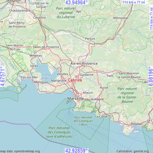
Cabriès GPS coordinates[2]
43° 26' 28.572" North, 5° 22' 43.824" East
| Map corner | latitude | longitude |
|---|---|---|
| Upper-left | 43.94964°, | 4.67571° |
| Center: | 43.44127°, | 5.37884° |
| Lower-right: | 42.92859°, | 6.08196° |
| Map W x H: | 113.5×113.5 km | = 70.5×70.5mi |
| max Lat: | 51.07786° ⇑93.8% North |
| Cabriès: | 43.44127° |
| min Lat: | ⇓6.2% South 41.3874° |
| min Long | Cabriès | max Long |
| -5.08615° | 5.37884° | 9.52242° |
| W 81.5%⇐ | ⇒18.5% E |
Elevation
Elevation of Cabriès is 203 m = 666 ft, and this is 9.3 m = 31 ft above average elevation for this country.
| Max E: |
2333 m = 7654 ft | 33.2% |
| Cabriès | 203 m 666 ft | |
| Avg. | 193.7 m = 635 ft | |
Min E: |
-1 m = -3 ft | 66.8% |
See also: France elevation on elevation.city.
Geographical zone
Cabriès is located in North temperate zone (between Tropic of Cancer and the Arctic Circle). Distance of this Northern Tropic circle is 2224.3 km =1382.1 mi to South.| Distance of | km | miles | from Cabriès |
|---|---|---|---|
| North Pole | 5176.8 | 3216.7 | to North |
| Arctic Circle | 2571 | 1597.5 | to North |
| Tropic Cancer | 2224.3 | 1382.1 | to South |
| Equator | 4830.2 | 3001.3 | to South |


Nearby cities:
15 places around Cabriès: (largest is in red/bold)
• Borel
8.6 km =5.3 mi,  186°
186°
• Bouc-Bel-Air
3 km =1.9 mi,  66°
66°
• Gardanne
7.4 km =4.6 mi,  78°
78°
• La Viste
9.3 km =5.8 mi, 191°
• Les Aygalades
9.4 km =5.8 mi,  183°
183°
• Les Pennes-Mirabeau
6.7 km =4.2 mi,  238°
238°
• Marseille 15
7.9 km =4.9 mi, 194°
• Marseille 16
9.7 km =6 mi,  201°
201°
• Mouret
9.8 km =6.1 mi,  155°
155°
• Notre-Dame Limite
6.8 km =4.2 mi, 191°
• Saint-Antoine
8 km =5 mi, 191°
• Saint-Henri
9.7 km =6 mi, 203°
• Septèmes-les-Vallons
4.9 km =3 mi, 192°
• Simiane-Collongue
4.6 km =2.9 mi,  104°
104°
• Verduron
8.3 km =5.2 mi, 199°
Sources, notices
• [Note1] Compared only with cities in France existing in our database
• [Src1] Map data: © OpenStreetMap contributors (CC-BY-SA)
• [Src2] Other city data from geonames.org with taken over terms of usage.
• [Src3] Geographical zone / Annual Mean Temperature by Robert A. Rohde @ Wikipedia
