Mouret geodata
Mouret (Provence-Alpes-Côte d'Azur) is a section of populated place; located in France in Europe/Paris (GMT+2) time zone. With population of 1,645 people, there are 5680 cities with bigger population in this country. Compared to other cities in France, 94.7% of cities are located further ↑North; 82.3% of cities are located further ←West and 63.6% of cities have lower elevation than Mouret. Note1
Administrative division(s):
- Level 1: Provence-Alpes-Côte d'Azur
- Level 2: Département des Bouches-du-Rhône
- Level 3: Arrondissement de Marseille
- Level 4: Marseille


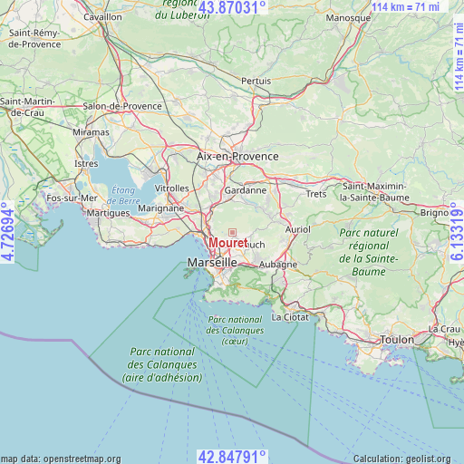
Mouret GPS coordinates[2]
43° 21' 40.536" North, 5° 25' 48.216" East
| Map corner | latitude | longitude |
|---|---|---|
| Upper-left | 43.87031°, | 4.72694° |
| Center: | 43.36126°, | 5.43006° |
| Lower-right: | 42.84791°, | 6.13319° |
| Map W x H: | 113.7×113.7 km | = 70.6×70.6mi |
| max Lat: | 51.07786° ⇑94.7% North |
| Mouret: | 43.36126° |
| min Lat: | ⇓5.3% South 41.3874° |
| min Long | Mouret | max Long |
| -5.08615° | 5.43006° | 9.52242° |
| W 82.3%⇐ | ⇒17.7% E |
Elevation
Elevation of Mouret is 187 m = 614 ft, and this is 6.7 m = 22 ft below average elevation for this country.
| Max E: |
2333 m = 7654 ft | 36.4% |
| Avg. | 193.7 m = 635 ft | |
| Mouret | 187 m = 614 ft | |
Min E: |
-1 m = -3 ft | 63.6% |
See also: France elevation on elevation.city.
Geographical zone
Mouret is located in North temperate zone (between Tropic of Cancer and the Arctic Circle). Distance of this Northern Tropic circle is 2215.4 km =1376.6 mi to South.| Distance of | km | miles | from Mouret |
|---|---|---|---|
| North Pole | 5185.7 | 3222.2 | to North |
| Arctic Circle | 2579.9 | 1603.1 | to North |
| Tropic Cancer | 2215.4 | 1376.6 | to South |
| Equator | 4821.3 | 2995.8 | to South |


Nearby cities:
15 places around Mouret: (largest is in red/bold)
• La Croix-Rouge
3.7 km =2.3 mi,  148°
148°
• La Rose
3.6 km =2.2 mi,  181°
181°
• Le Merlan
3.1 km =1.9 mi,  215°
215°
• Les Aygalades
4.8 km =3 mi,  264°
264°
• Les Médecins
2.2 km =1.4 mi,  111°
111°
• Les Olives
4.7 km =2.9 mi, 151°
• Malpassé
4.6 km =2.9 mi,  194°
194°
• Marseille 14
4.5 km =2.8 mi,  245°
245°
• Palama
1.2 km =0.7 mi,  66°
66°
• Plan-de-Cuques
3.1 km =1.9 mi,  119°
119°
• Saint-Barthélémy
4 km =2.5 mi,  213°
213°
• Saint-Joseph
4.4 km =2.7 mi, 247°
• Saint-Jérôme
3.2 km =2 mi,  198°
198°
• Saint-Mitre
1.8 km =1.1 mi, 199°
• Sainte-Marthe
4.3 km =2.7 mi,  226°
226°
Sources, notices
• [Note1] Compared only with cities in France existing in our database
• [Src1] Map data: © OpenStreetMap contributors (CC-BY-SA)
• [Src2] Other city data from geonames.org with taken over terms of usage.
• [Src3] Geographical zone / Annual Mean Temperature by Robert A. Rohde @ Wikipedia
