Brunstatt geodata
Brunstatt (Grand Est) is a populated place; located in France in Europe/Paris (GMT+2) time zone. With population of 5,816 people, there are 1696 cities with bigger population in this country. Compared to other cities in France, 54.6% of cities are located further ↓South; 96.7% of cities are located further ←West and 81% of cities have lower elevation than Brunstatt. Note1
Administrative division(s):
- Level 1: Grand Est
- Level 2: Haut-Rhin
- Level 3: Arrondissement de Mulhouse
- Level 4: Brunstatt-Didenheim


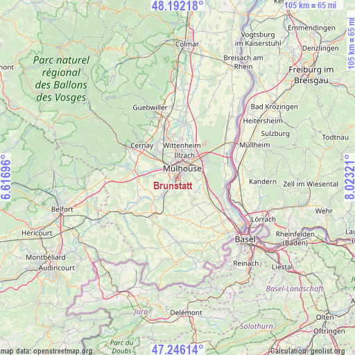
Brunstatt GPS coordinates[2]
47° 43' 16.716" North, 7° 19' 12.324" East
| Map corner | latitude | longitude |
|---|---|---|
| Upper-left | 48.19218°, | 6.61696° |
| Center: | 47.72131°, | 7.32009° |
| Lower-right: | 47.24614°, | 8.02321° |
| Map W x H: | 105.2×105.2 km | = 65.4×65.4mi |
| max Lat: | 51.07786° ⇑45.4% North |
| Brunstatt: | 47.72131° |
| min Lat: | ⇓54.6% South 41.3874° |
| min Long | Brunstatt | max Long |
| -5.08615° | 7.32009° | 9.52242° |
| W 96.7%⇐ | ⇒3.3% E |
Elevation
Elevation of Brunstatt is 300 m = 984 ft, and this is 106.3 m = 349 ft above average elevation for this country.
| Max E: |
2333 m = 7654 ft | 19% |
| Brunstatt | 300 m 984 ft | |
| Avg. | 193.7 m = 635 ft | |
Min E: |
-1 m = -3 ft | 81% |
See also: France elevation on elevation.city.
Geographical zone
Brunstatt is located in North temperate zone (between Tropic of Cancer and the Arctic Circle). Distance of this North polar circle is 2095.1 km =1301.8 mi to North.| Distance of | km | miles | from Brunstatt |
|---|---|---|---|
| North Pole | 4700.9 | 2921 | to North |
| Arctic Circle | 2095.1 | 1301.8 | to North |
| Tropic Cancer | 2700.2 | 1677.8 | to South |
| Equator | 5306.1 | 3297.1 | to South |


Nearby cities:
15 places around Brunstatt: (largest is in red/bold)
• Bruebach
3.7 km =2.3 mi,  128°
128°
• Didenheim
1.4 km =0.9 mi,  257°
257°
• Eschentzwiller
5.9 km =3.7 mi,  99°
99°
• Flaxlanden
2.9 km =1.8 mi,  187°
187°
• Frœningen
5.8 km =3.6 mi,  223°
223°
• Hochstatt
3.8 km =2.4 mi,  239°
239°
• Illzach
6.3 km =3.9 mi,  21°
21°
• Lutterbach
5.2 km =3.2 mi,  325°
325°
• Morschwiller-le-Bas
4.1 km =2.5 mi,  293°
293°
• Mulhouse
3.5 km =2.2 mi,  10°
10°
• Pfastatt
5.5 km =3.4 mi,  346°
346°
• Riedisheim
4.6 km =2.9 mi,  49°
49°
• Steinbrunn-le-Bas
6.2 km =3.9 mi,  145°
145°
• Zillisheim
3.3 km =2.1 mi,  211°
211°
• Zimmersheim
5.1 km =3.2 mi,  90°
90°
Sources, notices
• [Note1] Compared only with cities in France existing in our database
• [Src1] Map data: © OpenStreetMap contributors (CC-BY-SA)
• [Src2] Other city data from geonames.org with taken over terms of usage.
• [Src3] Geographical zone / Annual Mean Temperature by Robert A. Rohde @ Wikipedia
