Lutterbach geodata
Lutterbach (Grand Est) is a populated place; located in France in Europe/Paris (GMT+2) time zone. With population of 6,180 people, there are 1606 cities with bigger population in this country. Compared to other cities in France, 55.2% of cities are located further ↓South; 96.3% of cities are located further ←West and 75.6% of cities have lower elevation than Lutterbach. Note1
Administrative division(s):
- Level 1: Grand Est
- Level 2: Haut-Rhin
- Level 3: Arrondissement de Mulhouse
- Level 4: Lutterbach


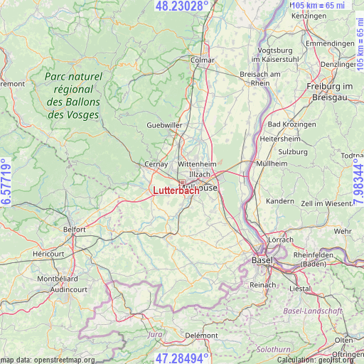
Lutterbach GPS coordinates[2]
47° 45' 35.136" North, 7° 16' 49.152" East
| Map corner | latitude | longitude |
|---|---|---|
| Upper-left | 48.23028°, | 6.57719° |
| Center: | 47.75976°, | 7.28032° |
| Lower-right: | 47.28494°, | 7.98344° |
| Map W x H: | 105.1×105.1 km | = 65.3×65.3mi |
| max Lat: | 51.07786° ⇑44.8% North |
| Lutterbach: | 47.75976° |
| min Lat: | ⇓55.2% South 41.3874° |
| min Long | Lutterbach | max Long |
| -5.08615° | 7.28032° | 9.52242° |
| W 96.3%⇐ | ⇒3.7% E |
Elevation
Elevation of Lutterbach is 254 m = 833 ft, and this is 60.3 m = 198 ft above average elevation for this country.
| Max E: |
2333 m = 7654 ft | 24.4% |
| Lutterbach | 254 m 833 ft | |
| Avg. | 193.7 m = 635 ft | |
Min E: |
-1 m = -3 ft | 75.6% |
See also: France elevation on elevation.city.
Geographical zone
Lutterbach is located in North temperate zone (between Tropic of Cancer and the Arctic Circle). Distance of this North polar circle is 2090.8 km =1299.2 mi to North.| Distance of | km | miles | from Lutterbach |
|---|---|---|---|
| North Pole | 4696.7 | 2918.4 | to North |
| Arctic Circle | 2090.8 | 1299.2 | to North |
| Tropic Cancer | 2704.5 | 1680.5 | to South |
| Equator | 5310.4 | 3299.7 | to South |


Nearby cities:
15 places around Lutterbach: (largest is in red/bold)
• Brunstatt
5.2 km =3.2 mi,  145°
145°
• Didenheim
4.8 km =3 mi,  160°
160°
• Heimsbrunn
5.4 km =3.4 mi,  227°
227°
• Hochstatt
6.2 km =3.9 mi,  182°
182°
• Illzach
5.6 km =3.5 mi,  73°
73°
• Kingersheim
4.9 km =3 mi,  44°
44°
• Morschwiller-le-Bas
2.7 km =1.7 mi,  197°
197°
• Mulhouse
3.7 km =2.3 mi,  103°
103°
• Pfastatt
2 km =1.2 mi,  58°
58°
• Reiningue
3.6 km =2.2 mi,  256°
256°
• Richwiller
2.2 km =1.4 mi,  0°
0°
• Riedisheim
6.6 km =4.1 mi, 100°
• Wittelsheim
6.2 km =3.9 mi,  332°
332°
• Wittenheim
6.7 km =4.2 mi,  31°
31°
• Zillisheim
7.2 km =4.5 mi,  169°
169°
Sources, notices
• [Note1] Compared only with cities in France existing in our database
• [Src1] Map data: © OpenStreetMap contributors (CC-BY-SA)
• [Src2] Other city data from geonames.org with taken over terms of usage.
• [Src3] Geographical zone / Annual Mean Temperature by Robert A. Rohde @ Wikipedia
