Mulhouse geodata
Mulhouse (Grand Est) is a seat of a third-order administrative division; located in France in Europe/Paris (GMT+2) time zone. With population of 111,430 people, there are 33 cities with bigger population in this country. Compared to other cities in France, 55% of cities are located further ↓South; 96.8% of cities are located further ←West and 74.9% of cities have lower elevation than Mulhouse. Note1
Administrative division(s):
- Level 1: Grand Est
- Level 2: Haut-Rhin
- Level 3: Arrondissement de Mulhouse
- Level 4: Mulhouse


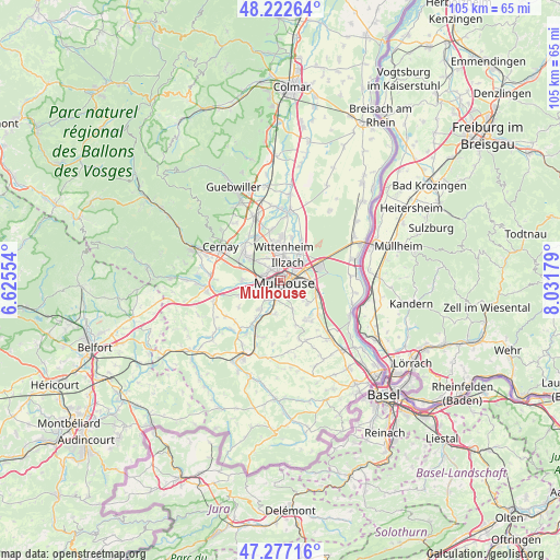
Mulhouse GPS coordinates[2]
47° 45' 7.38" North, 7° 19' 43.176" East
| Map corner | latitude | longitude |
|---|---|---|
| Upper-left | 48.22264°, | 6.62554° |
| Center: | 47.75205°, | 7.32866° |
| Lower-right: | 47.27716°, | 8.03179° |
| Map W x H: | 105.1×105.1 km | = 65.3×65.3mi |
| max Lat: | 51.07786° ⇑45% North |
| Mulhouse: | 47.75205° |
| min Lat: | ⇓55% South 41.3874° |
| min Long | Mulhouse | max Long |
| -5.08615° | 7.32866° | 9.52242° |
| W 96.8%⇐ | ⇒3.2% E |
Elevation
Elevation of Mulhouse is 248 m = 814 ft, and this is 54.3 m = 178 ft above average elevation for this country.
| Max E: |
2333 m = 7654 ft | 25.1% |
| Mulhouse | 248 m 814 ft | |
| Avg. | 193.7 m = 635 ft | |
Min E: |
-1 m = -3 ft | 74.9% |
See also: Mulhouse elevation on elevation.city.
Geographical zone
Mulhouse is located in North temperate zone (between Tropic of Cancer and the Arctic Circle). Distance of this North polar circle is 2091.6 km =1299.7 mi to North.| Distance of | km | miles | from Mulhouse |
|---|---|---|---|
| North Pole | 4697.5 | 2918.9 | to North |
| Arctic Circle | 2091.6 | 1299.7 | to North |
| Tropic Cancer | 2703.6 | 1679.9 | to South |
| Equator | 5309.5 | 3299.2 | to South |


Nearby cities:
15 places around Mulhouse: (largest is in red/bold)
• Bruebach
6.1 km =3.8 mi,  158°
158°
• Brunstatt
3.5 km =2.2 mi,  190°
190°
• Didenheim
4.2 km =2.6 mi,  208°
208°
• Flaxlanden
6.4 km =4 mi, 189°
• Illzach
3 km =1.9 mi,  35°
35°
• Kingersheim
4.3 km =2.7 mi,  357°
357°
• Lutterbach
3.7 km =2.3 mi,  283°
283°
• Morschwiller-le-Bas
4.8 km =3 mi,  248°
248°
• Pfastatt
2.7 km =1.7 mi,  314°
314°
• Richwiller
4.7 km =2.9 mi, 310°
• Riedisheim
2.9 km =1.8 mi,  97°
97°
• Rixheim
5.5 km =3.4 mi,  92°
92°
• Sausheim
5.1 km =3.2 mi, 40°
• Wittenheim
6.5 km =4 mi, 359°
• Zimmersheim
5.7 km =3.5 mi,  127°
127°
Sources, notices
• [Note1] Compared only with cities in France existing in our database
• [Src1] Map data: © OpenStreetMap contributors (CC-BY-SA)
• [Src2] Other city data from geonames.org with taken over terms of usage.
• [Src3] Geographical zone / Annual Mean Temperature by Robert A. Rohde @ Wikipedia
