Castelnau-de-Montmiral geodata
Castelnau-de-Montmiral (Occitanie) is a populated place; located in France in Europe/Paris (GMT+2) time zone. With population of 953 people, there are 9182 cities with bigger population in this country. Compared to other cities in France, 87.4% of cities are located further ↑North; 59.2% of cities are located further →East and 79.7% of cities have lower elevation than Castelnau-de-Montmiral. Note1
Administrative division(s):
- Level 1: Occitanie
- Level 2: Tarn
- Level 3: Albi
- Level 4: Castelnau-de-Montmiral


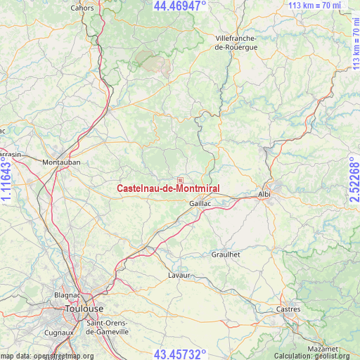
Castelnau-de-Montmiral GPS coordinates[2]
43° 57' 55.98" North, 1° 49' 10.416" East
| Map corner | latitude | longitude |
|---|---|---|
| Upper-left | 44.46947°, | 1.11643° |
| Center: | 43.96555°, | 1.81956° |
| Lower-right: | 43.45732°, | 2.52268° |
| Map W x H: | 112.5×112.5 km | = 69.9×69.9mi |
| max Lat: | 51.07786° ⇑87.4% North |
| Castelnau-de-Montmiral: | 43.96555° |
| min Lat: | ⇓12.6% South 41.3874° |
| min Long | Castelnau-de-Mo | max Long |
| -5.08615° | 1.81956° | 9.52242° |
| W 40.8%⇐ | ⇒59.2% E |
Elevation
Elevation of Castelnau-de-Montmiral is 287 m = 942 ft, and this is 93.3 m = 306 ft above average elevation for this country.
| Max E: |
2333 m = 7654 ft | 20.3% |
| Castelnau-de-Montmiral | 287 m 942 ft | |
| Avg. | 193.7 m = 635 ft | |
Min E: |
-1 m = -3 ft | 79.7% |
See also: France elevation on elevation.city.
Geographical zone
Castelnau-de-Montmiral is located in North temperate zone (between Tropic of Cancer and the Arctic Circle). Distance of this Northern Tropic circle is 2282.6 km =1418.3 mi to South.| Distance of | km | miles | from Castelnau-de-Montmiral |
|---|---|---|---|
| North Pole | 5118.6 | 3180.5 | to North |
| Arctic Circle | 2512.7 | 1561.3 | to North |
| Tropic Cancer | 2282.6 | 1418.3 | to South |
| Equator | 4888.5 | 3037.6 | to South |


Nearby cities:
15 places around Castelnau-de-Montmiral: (largest is in red/bold)
• Brens
11.2 km =7 mi,  141°
141°
• Bruniquel
15.9 km =9.9 mi,  308°
308°
• Cahuzac-sur-Vère
7.5 km =4.7 mi,  75°
75°
• Cordes-sur-Ciel
15.3 km =9.5 mi,  42°
42°
• Gaillac
9.4 km =5.8 mi, 138°
• Labastide-de-Lévis
15.8 km =9.8 mi,  105°
105°
• Lagrave
15.8 km =9.8 mi,  118°
118°
• Lisle-sur-Tarn
12.6 km =7.8 mi,  183°
183°
• Montans
12.2 km =7.6 mi,  154°
154°
• Penne
14.3 km =8.9 mi,  330°
330°
• Rabastens
17.4 km =10.8 mi,  206°
206°
• Rivières
12.8 km =8 mi, 116°
• Salvagnac
12.4 km =7.7 mi,  237°
237°
• Senouillac
10.6 km =6.6 mi,  104°
104°
• Técou
17.1 km =10.6 mi, 142°
Sources, notices
• [Note1] Compared only with cities in France existing in our database
• [Src1] Map data: © OpenStreetMap contributors (CC-BY-SA)
• [Src2] Other city data from geonames.org with taken over terms of usage.
• [Src3] Geographical zone / Annual Mean Temperature by Robert A. Rohde @ Wikipedia
