Bronvaux geodata
Bronvaux (Grand Est) is a populated place; located in France in Europe/Paris (GMT+2) time zone. With population of 569 people, there are 13839 cities with bigger population in this country. Compared to other cities in France, 84.2% of cities are located further ↓South; 88.1% of cities are located further ←West and 71.8% of cities have lower elevation than Bronvaux. Note1
Administrative division(s):
- Level 1: Grand Est
- Level 2: Moselle
- Level 3: Arrondissement de Metz
- Level 4: Bronvaux


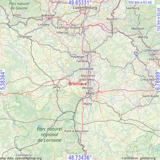
Bronvaux GPS coordinates[2]
49° 11' 45.492" North, 6° 5' 12.372" East
| Map corner | latitude | longitude |
|---|---|---|
| Upper-left | 49.65331°, | 5.38364° |
| Center: | 49.19597°, | 6.08677° |
| Lower-right: | 48.73436°, | 6.78989° |
| Map W x H: | 102.2×102.2 km | = 63.5×63.5mi |
| max Lat: | 51.07786° ⇑15.8% North |
| Bronvaux: | 49.19597° |
| min Lat: | ⇓84.2% South 41.3874° |
| min Long | Bronvaux | max Long |
| -5.08615° | 6.08677° | 9.52242° |
| W 88.1%⇐ | ⇒11.9% E |
Elevation
Elevation of Bronvaux is 229 m = 751 ft, and this is 35.3 m = 116 ft above average elevation for this country.
| Max E: |
2333 m = 7654 ft | 28.2% |
| Bronvaux | 229 m 751 ft | |
| Avg. | 193.7 m = 635 ft | |
Min E: |
-1 m = -3 ft | 71.8% |
See also: France elevation on elevation.city.
Geographical zone
Bronvaux is located in North temperate zone (between Tropic of Cancer and the Arctic Circle). Distance of this North polar circle is 1931.1 km =1199.9 mi to North.| Distance of | km | miles | from Bronvaux |
|---|---|---|---|
| North Pole | 4537 | 2819.2 | to North |
| Arctic Circle | 1931.1 | 1199.9 | to North |
| Tropic Cancer | 2864.2 | 1779.7 | to South |
| Equator | 5470.1 | 3399 | to South |


Nearby cities:
15 places around Bronvaux: (largest is in red/bold)
• Amanvillers
4.4 km =2.7 mi,  225°
225°
• Fèves
2.2 km =1.4 mi,  92°
92°
• Jœuf
6.6 km =4.1 mi,  309°
309°
• Maizières-lès-Metz
5.6 km =3.5 mi,  69°
69°
• Marange-Silvange
1.9 km =1.2 mi,  43°
43°
• Montois-la-Montagne
5.3 km =3.3 mi,  295°
295°
• Norroy-le-Veneur
2 km =1.2 mi,  141°
141°
• Pierrevillers
3.4 km =2.1 mi,  20°
20°
• Plesnois
2.9 km =1.8 mi,  151°
151°
• Rombas
6 km =3.7 mi,  5°
5°
• Roncourt
3.4 km =2.1 mi,  282°
282°
• Saint-Privat-la-Montagne
3.6 km =2.2 mi,  255°
255°
• Sainte-Marie-aux-Chênes
6.2 km =3.9 mi,  266°
266°
• Saulny
4.6 km =2.9 mi,  158°
158°
• Semécourt
3.7 km =2.3 mi, 92°
Sources, notices
• [Note1] Compared only with cities in France existing in our database
• [Src1] Map data: © OpenStreetMap contributors (CC-BY-SA)
• [Src2] Other city data from geonames.org with taken over terms of usage.
• [Src3] Geographical zone / Annual Mean Temperature by Robert A. Rohde @ Wikipedia
