Maizières-lès-Metz geodata
Maizières-lès-Metz (Grand Est) is a populated place; located in France in Europe/Paris (GMT+2) time zone. With population of 9,845 people, there are 965 cities with bigger population in this country. Compared to other cities in France, 84.5% of cities are located further ↓South; 88.9% of cities are located further ←West and 58.3% of cities have lower elevation than Maizières-lès-Metz. Note1
Administrative division(s):
- Level 1: Grand Est
- Level 2: Moselle
- Level 3: Arrondissement de Metz
- Level 4: Maizières-lès-Metz


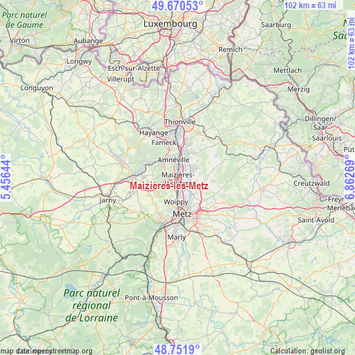
Maizières-lès-Metz GPS coordinates[2]
49° 12' 48.06" North, 6° 9' 34.416" East
| Map corner | latitude | longitude |
|---|---|---|
| Upper-left | 49.67053°, | 5.45644° |
| Center: | 49.21335°, | 6.15956° |
| Lower-right: | 48.7519°, | 6.86269° |
| Map W x H: | 102.1×102.1 km | = 63.4×63.4mi |
| max Lat: | 51.07786° ⇑15.5% North |
| Maizières-lès-Metz: | 49.21335° |
| min Lat: | ⇓84.5% South 41.3874° |
| min Long | Maizières-lès | max Long |
| -5.08615° | 6.15956° | 9.52242° |
| W 88.9%⇐ | ⇒11.1% E |
Elevation
Elevation of Maizières-lès-Metz is 162 m = 531 ft, and this is 31.7 m = 104 ft below average elevation for this country.
| Max E: |
2333 m = 7654 ft | 41.7% |
| Avg. | 193.7 m = 635 ft | |
| Maizières-lès-Metz | 162 m = 531 ft | |
Min E: |
-1 m = -3 ft | 58.3% |
See also: France elevation on elevation.city.
Geographical zone
Maizières-lès-Metz is located in North temperate zone (between Tropic of Cancer and the Arctic Circle). Distance of this North polar circle is 1929.2 km =1198.7 mi to North.| Distance of | km | miles | from Maizières-lès-Metz |
|---|---|---|---|
| North Pole | 4535.1 | 2818 | to North |
| Arctic Circle | 1929.2 | 1198.7 | to North |
| Tropic Cancer | 2866.1 | 1780.9 | to South |
| Equator | 5472 | 3400.1 | to South |


Nearby cities:
15 places around Maizières-lès-Metz: (largest is in red/bold)
• Amnéville
5.2 km =3.2 mi,  339°
339°
• Argancy
3.6 km =2.2 mi,  123°
123°
• Ay-sur-Moselle
4.8 km =3 mi,  45°
45°
• Bronvaux
5.6 km =3.5 mi,  249°
249°
• Ennery
4.5 km =2.8 mi,  71°
71°
• Fèves
3.7 km =2.3 mi,  236°
236°
• Hagondange
4 km =2.5 mi,  4°
4°
• Hauconcourt
2.3 km =1.4 mi, 73°
• La Maxe
5.5 km =3.4 mi,  156°
156°
• Marange-Silvange
4.1 km =2.5 mi,  261°
261°
• Mondelange
5.4 km =3.4 mi, 4°
• Norroy-le-Veneur
5.3 km =3.3 mi,  229°
229°
• Pierrevillers
4.3 km =2.7 mi,  287°
287°
• Semécourt
2.7 km =1.7 mi,  217°
217°
• Talange
2.6 km =1.6 mi,  19°
19°
Sources, notices
• [Note1] Compared only with cities in France existing in our database
• [Src1] Map data: © OpenStreetMap contributors (CC-BY-SA)
• [Src2] Other city data from geonames.org with taken over terms of usage.
• [Src3] Geographical zone / Annual Mean Temperature by Robert A. Rohde @ Wikipedia
