Brion geodata
Brion (Bourgogne-Franche-Comté) is a populated place; located in France in Europe/Paris (GMT+2) time zone. With population of 625 people, there are 12901 cities with bigger population in this country. Compared to other cities in France, 59.2% of cities are located further ↓South; 64% of cities are located further ←West and 52.3% of cities have higher elevation than Brion. Note1
Administrative division(s):
- Level 1: Bourgogne-Franche-Comté
- Level 2: Département de l'Yonne
- Level 3: Arrondissement de Sens
- Level 4: Brion


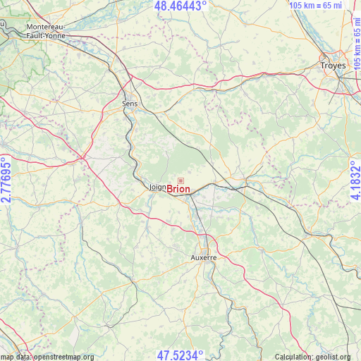
Brion GPS coordinates[2]
47° 59' 45.816" North, 3° 28' 48.288" East
| Map corner | latitude | longitude |
|---|---|---|
| Upper-left | 48.46443°, | 2.77695° |
| Center: | 47.99606°, | 3.48008° |
| Lower-right: | 47.5234°, | 4.1832° |
| Map W x H: | 104.6×104.6 km | = 65×65mi |
| max Lat: | 51.07786° ⇑40.8% North |
| Brion: | 47.99606° |
| min Lat: | ⇓59.2% South 41.3874° |
| min Long | Brion | max Long |
| -5.08615° | 3.48008° | 9.52242° |
| W 64%⇐ | ⇒36% E |
Elevation
Elevation of Brion is 124 m = 407 ft, and this is 69.7 m = 229 ft below average elevation for this country.
| Max E: |
2333 m = 7654 ft | 52.3% |
| Avg. | 193.7 m = 635 ft | |
| Brion | 124 m = 407 ft | |
Min E: |
-1 m = -3 ft | 47.7% |
See also: France elevation on elevation.city.
Geographical zone
Brion is located in North temperate zone (between Tropic of Cancer and the Arctic Circle). Distance of this North polar circle is 2064.5 km =1282.8 mi to North.| Distance of | km | miles | from Brion |
|---|---|---|---|
| North Pole | 4670.4 | 2902.1 | to North |
| Arctic Circle | 2064.5 | 1282.8 | to North |
| Tropic Cancer | 2730.7 | 1696.8 | to South |
| Equator | 5336.7 | 3316.1 | to South |


Nearby cities:
15 places around Brion: (largest is in red/bold)
• Bassou
8.4 km =5.2 mi,  162°
162°
• Bonnard
8.7 km =5.4 mi, 156°
• Brienon-sur-Armançon
10.2 km =6.3 mi,  93°
93°
• Bussy-en-Othe
3.6 km =2.2 mi,  43°
43°
• Champlay
5.9 km =3.7 mi,  211°
211°
• Chamvres
9.8 km =6.1 mi,  243°
243°
• Cheny
6.3 km =3.9 mi,  141°
141°
• Cézy
10.4 km =6.5 mi,  267°
267°
• Dixmont
10.7 km =6.6 mi,  332°
332°
• Joigny
6.1 km =3.8 mi,  256°
256°
• Laroche-Saint-Cydroine
3.1 km =1.9 mi,  173°
173°
• Migennes
4.4 km =2.7 mi, 140°
• Mont-Saint-Sulpice
11.9 km =7.4 mi,  113°
113°
• Ormoy
8.4 km =5.2 mi,  124°
124°
• Épineau-les-Voves
5 km =3.1 mi,  178°
178°
Sources, notices
• [Note1] Compared only with cities in France existing in our database
• [Src1] Map data: © OpenStreetMap contributors (CC-BY-SA)
• [Src2] Other city data from geonames.org with taken over terms of usage.
• [Src3] Geographical zone / Annual Mean Temperature by Robert A. Rohde @ Wikipedia
