Bussy-en-Othe geodata
Bussy-en-Othe (Bourgogne-Franche-Comté) is a populated place; located in France in Europe/Paris (GMT+2) time zone. With population of 771 people, there are 10923 cities with bigger population in this country. Compared to other cities in France, 59.6% of cities are located further ↓South; 64.4% of cities are located further ←West and 57.6% of cities have lower elevation than Bussy-en-Othe. Note1
Administrative division(s):
- Level 1: Bourgogne-Franche-Comté
- Level 2: Département de l'Yonne
- Level 3: Arrondissement de Sens
- Level 4: Bussy-en-Othe


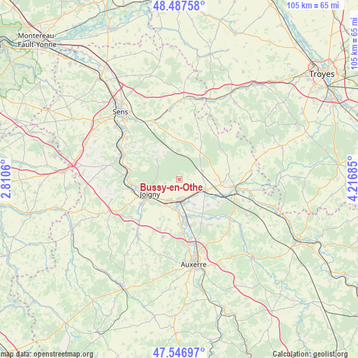
Bussy-en-Othe GPS coordinates[2]
48° 1' 9.912" North, 3° 30' 49.392" East
| Map corner | latitude | longitude |
|---|---|---|
| Upper-left | 48.48758°, | 2.8106° |
| Center: | 48.01942°, | 3.51372° |
| Lower-right: | 47.54697°, | 4.21685° |
| Map W x H: | 104.6×104.6 km | = 65×65mi |
| max Lat: | 51.07786° ⇑40.4% North |
| Bussy-en-Othe: | 48.01942° |
| min Lat: | ⇓59.6% South 41.3874° |
| min Long | Bussy-en-Othe | max Long |
| -5.08615° | 3.51372° | 9.52242° |
| W 64.4%⇐ | ⇒35.6% E |
Elevation
Elevation of Bussy-en-Othe is 160 m = 525 ft, and this is 33.7 m = 111 ft below average elevation for this country.
| Max E: |
2333 m = 7654 ft | 42.4% |
| Avg. | 193.7 m = 635 ft | |
| Bussy-en-Othe | 160 m = 525 ft | |
Min E: |
-1 m = -3 ft | 57.6% |
See also: France elevation on elevation.city.
Geographical zone
Bussy-en-Othe is located in North temperate zone (between Tropic of Cancer and the Arctic Circle). Distance of this North polar circle is 2061.9 km =1281.2 mi to North.| Distance of | km | miles | from Bussy-en-Othe |
|---|---|---|---|
| North Pole | 4667.8 | 2900.4 | to North |
| Arctic Circle | 2061.9 | 1281.2 | to North |
| Tropic Cancer | 2733.3 | 1698.4 | to South |
| Equator | 5339.3 | 3317.7 | to South |


Nearby cities:
15 places around Bussy-en-Othe: (largest is in red/bold)
• Arces-Dilo
9.6 km =6 mi,  42°
42°
• Bassou
10.6 km =6.6 mi,  179°
179°
• Bonnard
10.6 km =6.6 mi,  174°
174°
• Brienon-sur-Armançon
8.3 km =5.2 mi,  113°
113°
• Brion
3.6 km =2.2 mi,  223°
223°
• Champlay
9.4 km =5.8 mi, 216°
• Champlost
11.6 km =7.2 mi,  87°
87°
• Cheny
7.7 km =4.8 mi, 168°
• Dixmont
10.2 km =6.3 mi,  313°
313°
• Joigny
9.3 km =5.8 mi,  244°
244°
• Laroche-Saint-Cydroine
6.1 km =3.8 mi,  200°
200°
• Migennes
6 km =3.7 mi, 177°
• Mont-Saint-Sulpice
11.1 km =6.9 mi,  131°
131°
• Ormoy
8.6 km =5.3 mi,  148°
148°
• Épineau-les-Voves
8 km =5 mi, 197°
Sources, notices
• [Note1] Compared only with cities in France existing in our database
• [Src1] Map data: © OpenStreetMap contributors (CC-BY-SA)
• [Src2] Other city data from geonames.org with taken over terms of usage.
• [Src3] Geographical zone / Annual Mean Temperature by Robert A. Rohde @ Wikipedia
