Breitenbach geodata
Breitenbach (Grand Est) is a populated place; located in France in Europe/Paris (GMT+2) time zone. With population of 701 people, there are 11792 cities with bigger population in this country. Compared to other cities in France, 65.7% of cities are located further ↓South; 96.4% of cities are located further ←West and 86.2% of cities have lower elevation than Breitenbach. Note1
Administrative division(s):
- Level 1: Grand Est
- Level 2: Bas-Rhin
- Level 3: Arrondissement de Sélestat-Erstein
- Level 4: Breitenbach


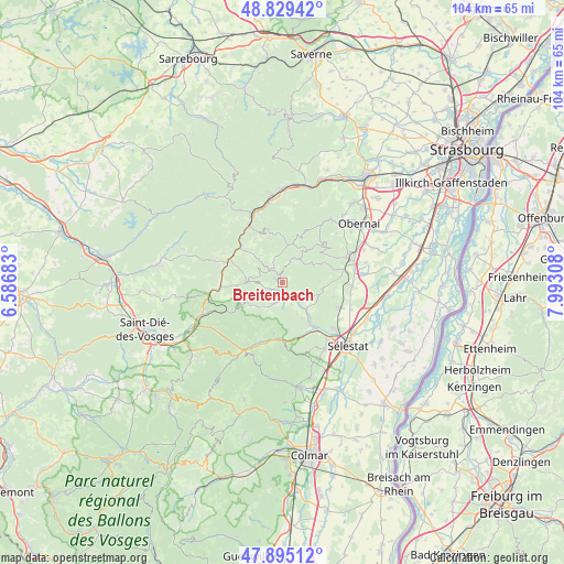
Breitenbach GPS coordinates[2]
48° 21' 51.876" North, 7° 17' 23.82" East
| Map corner | latitude | longitude |
|---|---|---|
| Upper-left | 48.82942°, | 6.58683° |
| Center: | 48.36441°, | 7.28995° |
| Lower-right: | 47.89512°, | 7.99308° |
| Map W x H: | 103.9×103.9 km | = 64.6×64.6mi |
| max Lat: | 51.07786° ⇑34.3% North |
| Breitenbach: | 48.36441° |
| min Lat: | ⇓65.7% South 41.3874° |
| min Long | Breitenbach | max Long |
| -5.08615° | 7.28995° | 9.52242° |
| W 96.4%⇐ | ⇒3.6% E |
Elevation
Elevation of Breitenbach is 363 m = 1191 ft, and this is 169.3 m = 555 ft above average elevation for this country.
| Max E: |
2333 m = 7654 ft | 13.8% |
| Breitenbach | 363 m 1191 ft | |
| Avg. | 193.7 m = 635 ft | |
Min E: |
-1 m = -3 ft | 86.2% |
See also: France elevation on elevation.city.
Geographical zone
Breitenbach is located in North temperate zone (between Tropic of Cancer and the Arctic Circle). Distance of this North polar circle is 2023.6 km =1257.4 mi to North.| Distance of | km | miles | from Breitenbach |
|---|---|---|---|
| North Pole | 4629.4 | 2876.6 | to North |
| Arctic Circle | 2023.6 | 1257.4 | to North |
| Tropic Cancer | 2771.7 | 1722.3 | to South |
| Equator | 5377.6 | 3341.5 | to South |


Nearby cities:
15 places around Breitenbach: (largest is in red/bold)
• Andlau
9.7 km =6 mi,  75°
75°
• Dambach-la-Ville
11 km =6.8 mi,  114°
114°
• Dieffenbach-au-Val
6.1 km =3.8 mi,  153°
153°
• Fouchy
4.3 km =2.7 mi,  198°
198°
• Lièpvre
10.3 km =6.4 mi,  183°
183°
• Maisonsgoutte
2.4 km =1.5 mi,  237°
237°
• Mittelbergheim
11.8 km =7.3 mi,  72°
72°
• Natzwiller
8.5 km =5.3 mi,  343°
343°
• Neubois
7.5 km =4.7 mi, 150°
• Neuve-Église
4.3 km =2.7 mi,  156°
156°
• Rombach-le-Franc
9.3 km =5.8 mi,  192°
192°
• Rothau
11.9 km =7.4 mi,  329°
329°
• Saint-Pierre-Bois
6.7 km =4.2 mi,  125°
125°
• Steige
4.1 km =2.5 mi,  266°
266°
• Villé
2.6 km =1.6 mi, 158°
Sources, notices
• [Note1] Compared only with cities in France existing in our database
• [Src1] Map data: © OpenStreetMap contributors (CC-BY-SA)
• [Src2] Other city data from geonames.org with taken over terms of usage.
• [Src3] Geographical zone / Annual Mean Temperature by Robert A. Rohde @ Wikipedia
