Bréal-sous-Montfort geodata
Bréal-sous-Montfort (Brittany) is a populated place; located in France in Europe/Paris (GMT+2) time zone. With population of 4,168 people, there are 2356 cities with bigger population in this country. Compared to other cities in France, 60.2% of cities are located further ↓South; 94.3% of cities are located further →East and 79.4% of cities have higher elevation than Bréal-sous-Montfort. Note1
Administrative division(s):
- Level 1: Brittany
- Level 2: Département d'Ille-et-Vilaine
- Level 3: Arrondissement de Rennes
- Level 4: Bréal-sous-Montfort


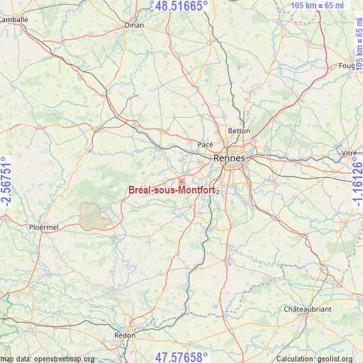
Bréal-sous-Montfort GPS coordinates[2]
48° 2' 55.536" North, 1° 51' 51.768" West
| Map corner | latitude | longitude |
|---|---|---|
| Upper-left | 48.51665°, | -2.56751° |
| Center: | 48.04876°, | -1.86438° |
| Lower-right: | 47.57658°, | -1.16126° |
| Map W x H: | 104.5×104.5 km | = 64.9×64.9mi |
| max Lat: | 51.07786° ⇑39.8% North |
| Bréal-sous-Montfort: | 48.04876° |
| min Lat: | ⇓60.2% South 41.3874° |
| min Long | Bréal-sous-Mon | max Long |
| -5.08615° | -1.86438° | 9.52242° |
| W 5.7%⇐ | ⇒94.3% E |
Elevation
Elevation of Bréal-sous-Montfort is 56 m = 184 ft, and this is 137.7 m = 452 ft below average elevation for this country.
| Max E: |
2333 m = 7654 ft | 79.4% |
| Avg. | 193.7 m = 635 ft | |
| Bréal-sous-Montfort | 56 m = 184 ft | |
Min E: |
-1 m = -3 ft | 20.6% |
See also: France elevation on elevation.city.
Geographical zone
Bréal-sous-Montfort is located in North temperate zone (between Tropic of Cancer and the Arctic Circle). Distance of this North polar circle is 2058.7 km =1279.2 mi to North.| Distance of | km | miles | from Bréal-sous-Montfort |
|---|---|---|---|
| North Pole | 4664.5 | 2898.4 | to North |
| Arctic Circle | 2058.7 | 1279.2 | to North |
| Tropic Cancer | 2736.6 | 1700.4 | to South |
| Equator | 5342.5 | 3319.7 | to South |


Nearby cities:
15 places around Bréal-sous-Montfort: (largest is in red/bold)
• Baulon
8.6 km =5.3 mi,  215°
215°
• Bruz
9.2 km =5.7 mi,  107°
107°
• Chavagne
5.9 km =3.7 mi,  83°
83°
• Cintré
6.3 km =3.9 mi,  355°
355°
• Goven
4.9 km =3 mi,  164°
164°
• Guichen
10.4 km =6.5 mi,  150°
150°
• La Chapelle-Thouarault
8.5 km =5.3 mi, 359°
• Lassy
7.9 km =4.9 mi,  184°
184°
• Le Rheu
7.8 km =4.8 mi,  39°
39°
• Monterfil
8.8 km =5.5 mi,  283°
283°
• Mordelles
3.4 km =2.1 mi,  28°
28°
• Saint-Jacques-de-la-Lande
10.8 km =6.7 mi, 80°
• Saint-Thurial
5.5 km =3.4 mi,  246°
246°
• Talensac
8.2 km =5.1 mi,  324°
324°
• Treffendel
10.6 km =6.6 mi,  264°
264°
Sources, notices
• [Note1] Compared only with cities in France existing in our database
• [Src1] Map data: © OpenStreetMap contributors (CC-BY-SA)
• [Src2] Other city data from geonames.org with taken over terms of usage.
• [Src3] Geographical zone / Annual Mean Temperature by Robert A. Rohde @ Wikipedia
