Saint-Thurial geodata
Saint-Thurial (Brittany) is a populated place; located in France in Europe/Paris (GMT+2) time zone. With population of 1,770 people, there are 5357 cities with bigger population in this country. Compared to other cities in France, 59.8% of cities are located further ↓South; 94.6% of cities are located further →East and 72.6% of cities have higher elevation than Saint-Thurial. Note1
Administrative division(s):
- Level 1: Brittany
- Level 2: Département d'Ille-et-Vilaine
- Level 3: Arrondissement de Rennes
- Level 4: Saint-Thurial


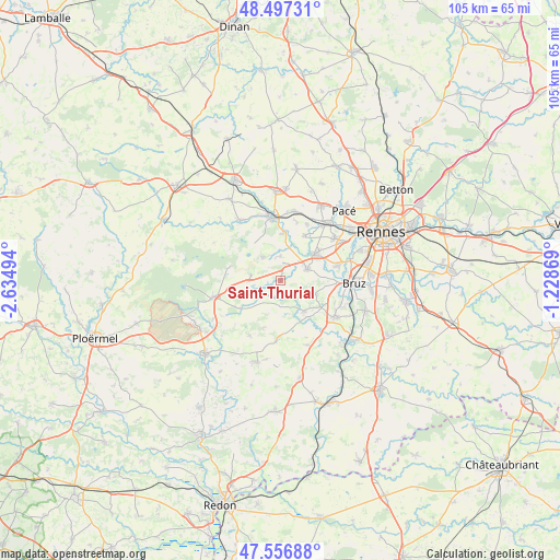
Saint-Thurial GPS coordinates[2]
48° 1' 45.264" North, 1° 55' 54.516" West
| Map corner | latitude | longitude |
|---|---|---|
| Upper-left | 48.49731°, | -2.63494° |
| Center: | 48.02924°, | -1.93181° |
| Lower-right: | 47.55688°, | -1.22869° |
| Map W x H: | 104.6×104.6 km | = 65×65mi |
| max Lat: | 51.07786° ⇑40.2% North |
| Saint-Thurial: | 48.02924° |
| min Lat: | ⇓59.8% South 41.3874° |
| min Long | Saint-Thurial | max Long |
| -5.08615° | -1.93181° | 9.52242° |
| W 5.4%⇐ | ⇒94.6% E |
Elevation
Elevation of Saint-Thurial is 72 m = 236 ft, and this is 121.7 m = 399 ft below average elevation for this country.
| Max E: |
2333 m = 7654 ft | 72.6% |
| Avg. | 193.7 m = 635 ft | |
| Saint-Thurial | 72 m = 236 ft | |
Min E: |
-1 m = -3 ft | 27.4% |
See also: France elevation on elevation.city.
Geographical zone
Saint-Thurial is located in North temperate zone (between Tropic of Cancer and the Arctic Circle). Distance of this North polar circle is 2060.8 km =1280.5 mi to North.| Distance of | km | miles | from Saint-Thurial |
|---|---|---|---|
| North Pole | 4666.7 | 2899.8 | to North |
| Arctic Circle | 2060.8 | 1280.5 | to North |
| Tropic Cancer | 2734.4 | 1699.1 | to South |
| Equator | 5340.4 | 3318.4 | to South |


Nearby cities:
15 places around Saint-Thurial: (largest is in red/bold)
• Baulon
4.8 km =3 mi,  179°
179°
• Bréal-sous-Montfort
5.5 km =3.4 mi,  66°
66°
• Chavagne
11.2 km =7 mi,  75°
75°
• Cintré
9.5 km =5.9 mi,  27°
27°
• Goven
6.8 km =4.2 mi,  111°
111°
• Guichen
12.2 km =7.6 mi,  124°
124°
• La Chapelle-Bouexic
11.2 km =7 mi, 183°
• La Chapelle-Thouarault
11.7 km =7.3 mi,  24°
24°
• Lassy
7.2 km =4.5 mi,  141°
141°
• Maxent
9.1 km =5.7 mi,  235°
235°
• Monterfil
5.5 km =3.4 mi,  320°
320°
• Montfort-sur-Meu
11.9 km =7.4 mi,  352°
352°
• Mordelles
8.4 km =5.2 mi,  51°
51°
• Talensac
8.8 km =5.5 mi,  1°
1°
• Treffendel
5.6 km =3.5 mi,  281°
281°
Sources, notices
• [Note1] Compared only with cities in France existing in our database
• [Src1] Map data: © OpenStreetMap contributors (CC-BY-SA)
• [Src2] Other city data from geonames.org with taken over terms of usage.
• [Src3] Geographical zone / Annual Mean Temperature by Robert A. Rohde @ Wikipedia
