Chavagne geodata
Chavagne (Brittany) is a populated place; located in France in Europe/Paris (GMT+2) time zone. With population of 3,378 people, there are 2882 cities with bigger population in this country. Compared to other cities in France, 60.3% of cities are located further ↓South; 94% of cities are located further →East and 89.1% of cities have higher elevation than Chavagne. Note1
Administrative division(s):
- Level 1: Brittany
- Level 2: Département d'Ille-et-Vilaine
- Level 3: Arrondissement de Rennes
- Level 4: Chavagne


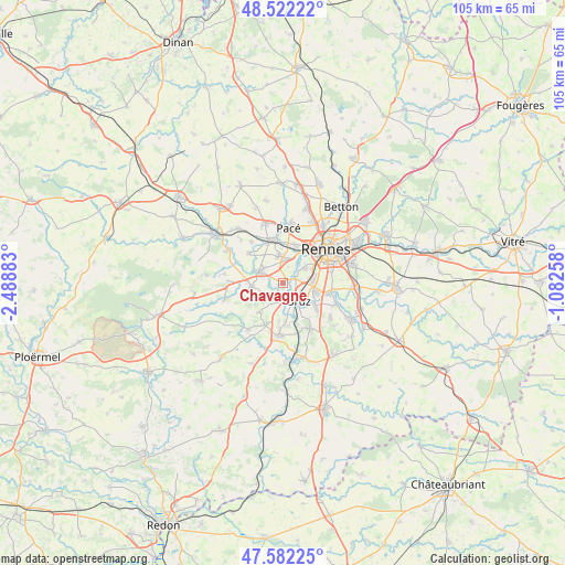
Chavagne GPS coordinates[2]
48° 3' 15.768" North, 1° 47' 8.556" West
| Map corner | latitude | longitude |
|---|---|---|
| Upper-left | 48.52222°, | -2.48883° |
| Center: | 48.05438°, | -1.78571° |
| Lower-right: | 47.58225°, | -1.08258° |
| Map W x H: | 104.5×104.5 km | = 64.9×64.9mi |
| max Lat: | 51.07786° ⇑39.7% North |
| Chavagne: | 48.05438° |
| min Lat: | ⇓60.3% South 41.3874° |
| min Long | Chavagne | max Long |
| -5.08615° | -1.78571° | 9.52242° |
| W 6%⇐ | ⇒94% E |
Elevation
Elevation of Chavagne is 32 m = 105 ft, and this is 161.7 m = 531 ft below average elevation for this country.
| Max E: |
2333 m = 7654 ft | 89.1% |
| Avg. | 193.7 m = 635 ft | |
| Chavagne | 32 m = 105 ft | |
Min E: |
-1 m = -3 ft | 10.9% |
See also: France elevation on elevation.city.
Geographical zone
Chavagne is located in North temperate zone (between Tropic of Cancer and the Arctic Circle). Distance of this North polar circle is 2058 km =1278.8 mi to North.| Distance of | km | miles | from Chavagne |
|---|---|---|---|
| North Pole | 4663.9 | 2898 | to North |
| Arctic Circle | 2058 | 1278.8 | to North |
| Tropic Cancer | 2737.2 | 1700.8 | to South |
| Equator | 5343.1 | 3320 | to South |


Nearby cities:
15 places around Chavagne: (largest is in red/bold)
• Bruz
4.5 km =2.8 mi,  138°
138°
• Bréal-sous-Montfort
5.9 km =3.7 mi,  263°
263°
• Chartres-de-Bretagne
6.2 km =3.9 mi,  105°
105°
• Châtillon-sur-Seiche
8.8 km =5.5 mi,  104°
104°
• Cintré
8.5 km =5.3 mi,  311°
311°
• Goven
7 km =4.3 mi,  220°
220°
• Guichen
9.7 km =6 mi,  184°
184°
• La Chapelle-Thouarault
9.9 km =6.2 mi,  322°
322°
• Laillé
9.9 km =6.2 mi,  148°
148°
• Le Rheu
5.4 km =3.4 mi,  350°
350°
• Mordelles
4.9 km =3 mi,  299°
299°
• Pacé
10.5 km =6.5 mi,  5°
5°
• Rennes
10.5 km =6.5 mi,  52°
52°
• Saint-Jacques-de-la-Lande
5 km =3.1 mi,  76°
76°
• Vezin-le-Coquet
7.5 km =4.7 mi,  17°
17°
Sources, notices
• [Note1] Compared only with cities in France existing in our database
• [Src1] Map data: © OpenStreetMap contributors (CC-BY-SA)
• [Src2] Other city data from geonames.org with taken over terms of usage.
• [Src3] Geographical zone / Annual Mean Temperature by Robert A. Rohde @ Wikipedia
