Boynes geodata
Boynes (Centre) is a populated place; located in France in Europe/Paris (GMT+2) time zone. With population of 1,098 people, there are 8143 cities with bigger population in this country. Compared to other cities in France, 61.5% of cities are located further ↓South; 51.7% of cities are located further →East and 56.5% of cities have higher elevation than Boynes. Note1
Administrative division(s):
- Level 1: Centre
- Level 2: Loiret
- Level 3: Arrondissement de Pithiviers
- Level 4: Boynes


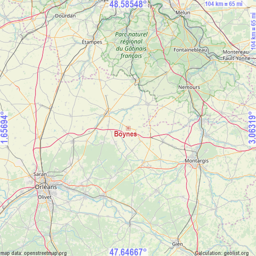
Boynes GPS coordinates[2]
48° 7' 5.592" North, 2° 21' 36.216" East
| Map corner | latitude | longitude |
|---|---|---|
| Upper-left | 48.58548°, | 1.65694° |
| Center: | 48.11822°, | 2.36006° |
| Lower-right: | 47.64667°, | 3.06319° |
| Map W x H: | 104.4×104.4 km | = 64.9×64.9mi |
| max Lat: | 51.07786° ⇑38.5% North |
| Boynes: | 48.11822° |
| min Lat: | ⇓61.5% South 41.3874° |
| min Long | Boynes | max Long |
| -5.08615° | 2.36006° | 9.52242° |
| W 48.3%⇐ | ⇒51.7% E |
Elevation
Elevation of Boynes is 112 m = 367 ft, and this is 81.7 m = 268 ft below average elevation for this country.
| Max E: |
2333 m = 7654 ft | 56.5% |
| Avg. | 193.7 m = 635 ft | |
| Boynes | 112 m = 367 ft | |
Min E: |
-1 m = -3 ft | 43.5% |
See also: France elevation on elevation.city.
Geographical zone
Boynes is located in North temperate zone (between Tropic of Cancer and the Arctic Circle). Distance of this North polar circle is 2050.9 km =1274.4 mi to North.| Distance of | km | miles | from Boynes |
|---|---|---|---|
| North Pole | 4656.8 | 2893.6 | to North |
| Arctic Circle | 2050.9 | 1274.4 | to North |
| Tropic Cancer | 2744.3 | 1705.2 | to South |
| Equator | 5350.2 | 3324.5 | to South |


Nearby cities:
15 places around Boynes: (largest is in red/bold)
• Ascoux
7.9 km =4.9 mi,  278°
278°
• Aulnay-la-Rivière
8.1 km =5 mi,  3°
3°
• Auxy
8.5 km =5.3 mi,  89°
89°
• Beaumont-du-Gâtinais
9.1 km =5.7 mi,  75°
75°
• Beaune-la-Rolande
7.4 km =4.6 mi,  134°
134°
• Boiscommun
9.3 km =5.8 mi,  169°
169°
• Chambon-la-Forêt
8.4 km =5.2 mi,  215°
215°
• Dadonville
7.9 km =4.9 mi,  303°
303°
• Estouy
8 km =5 mi,  343°
343°
• Mareau-aux-Bois
12.8 km =8 mi,  262°
262°
• Nibelle
11 km =6.8 mi,  192°
192°
• Pithiviers
10 km =6.2 mi,  306°
306°
• Pithiviers-le-Vieil
12.3 km =7.6 mi,  294°
294°
• Vrigny
9.2 km =5.7 mi,  242°
242°
• Yèvre-la-Ville
3.9 km =2.4 mi,  319°
319°
Sources, notices
• [Note1] Compared only with cities in France existing in our database
• [Src1] Map data: © OpenStreetMap contributors (CC-BY-SA)
• [Src2] Other city data from geonames.org with taken over terms of usage.
• [Src3] Geographical zone / Annual Mean Temperature by Robert A. Rohde @ Wikipedia
