Pithiviers geodata
Pithiviers (Centre) is a seat of a third-order administrative division; located in France in Europe/Paris (GMT+2) time zone. With population of 9,659 people, there are 985 cities with bigger population in this country. Compared to other cities in France, 62.3% of cities are located further ↓South; 53.5% of cities are located further →East and 58.7% of cities have higher elevation than Pithiviers. Note1
Administrative division(s):
- Level 1: Centre
- Level 2: Loiret
- Level 3: Arrondissement de Pithiviers
- Level 4: Pithiviers


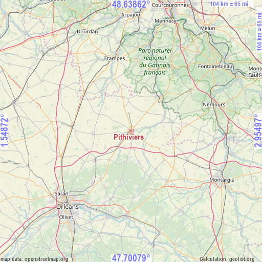
Pithiviers GPS coordinates[2]
48° 10' 18.66" North, 2° 15' 6.66" East
| Map corner | latitude | longitude |
|---|---|---|
| Upper-left | 48.63862°, | 1.54872° |
| Center: | 48.17185°, | 2.25185° |
| Lower-right: | 47.70079°, | 2.95497° |
| Map W x H: | 104.3×104.3 km | = 64.8×64.8mi |
| max Lat: | 51.07786° ⇑37.7% North |
| Pithiviers: | 48.17185° |
| min Lat: | ⇓62.3% South 41.3874° |
| min Long | Pithiviers | max Long |
| -5.08615° | 2.25185° | 9.52242° |
| W 46.5%⇐ | ⇒53.5% E |
Elevation
Elevation of Pithiviers is 106 m = 348 ft, and this is 87.7 m = 288 ft below average elevation for this country.
| Max E: |
2333 m = 7654 ft | 58.7% |
| Avg. | 193.7 m = 635 ft | |
| Pithiviers | 106 m = 348 ft | |
Min E: |
-1 m = -3 ft | 41.3% |
See also: France elevation on elevation.city.
Geographical zone
Pithiviers is located in North temperate zone (between Tropic of Cancer and the Arctic Circle). Distance of this North polar circle is 2045 km =1270.7 mi to North.| Distance of | km | miles | from Pithiviers |
|---|---|---|---|
| North Pole | 4650.9 | 2889.9 | to North |
| Arctic Circle | 2045 | 1270.7 | to North |
| Tropic Cancer | 2750.3 | 1709 | to South |
| Equator | 5356.2 | 3328.2 | to South |


Nearby cities:
15 places around Pithiviers: (largest is in red/bold)
• Ascoux
4.8 km =3 mi,  177°
177°
• Aulnay-la-Rivière
8.8 km =5.5 mi,  76°
76°
• Boynes
10 km =6.2 mi,  126°
126°
• Briarres-sur-Essonne
14 km =8.7 mi,  60°
60°
• Chambon-la-Forêt
13.2 km =8.2 mi,  165°
165°
• Chilleurs-aux-Bois
14.1 km =8.8 mi,  217°
217°
• Dadonville
2.1 km =1.3 mi,  137°
137°
• Escrennes
6.4 km =4 mi,  227°
227°
• Estouy
6 km =3.7 mi,  73°
73°
• Greneville-en-Beauce
10.5 km =6.5 mi,  276°
276°
• Manchecourt
10 km =6.2 mi,  42°
42°
• Mareau-aux-Bois
8.9 km =5.5 mi,  211°
211°
• Pithiviers-le-Vieil
3.3 km =2.1 mi,  252°
252°
• Vrigny
10.2 km =6.3 mi, 180°
• Yèvre-la-Ville
6.3 km =3.9 mi,  118°
118°
Sources, notices
• [Note1] Compared only with cities in France existing in our database
• [Src1] Map data: © OpenStreetMap contributors (CC-BY-SA)
• [Src2] Other city data from geonames.org with taken over terms of usage.
• [Src3] Geographical zone / Annual Mean Temperature by Robert A. Rohde @ Wikipedia
