Bourg geodata
Bourg (Nouvelle-Aquitaine) is a populated place; located in France in Europe/Paris (GMT+2) time zone. With population of 2,323 people, there are 4159 cities with bigger population in this country. Compared to other cities in France, 79.2% of cities are located further ↑North; 84% of cities are located further →East and 89.1% of cities have higher elevation than Bourg. Note1
Administrative division(s):
- Level 1: Nouvelle-Aquitaine
- Level 2: Gironde
- Level 3: Arrondissement de Blaye
- Level 4: Bourg


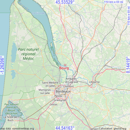
Bourg GPS coordinates[2]
45° 2' 26.232" North, 0° 33' 32.148" West
| Map corner | latitude | longitude |
|---|---|---|
| Upper-left | 45.53529°, | -1.26206° |
| Center: | 45.04062°, | -0.55893° |
| Lower-right: | 44.54163°, | 0.14419° |
| Map W x H: | 110.5×110.5 km | = 68.7×68.7mi |
| max Lat: | 51.07786° ⇑79.2% North |
| Bourg: | 45.04062° |
| min Lat: | ⇓20.8% South 41.3874° |
| min Long | Bourg | max Long |
| -5.08615° | -0.55893° | 9.52242° |
| W 16%⇐ | ⇒84% E |
Elevation
Elevation of Bourg is 32 m = 105 ft, and this is 161.7 m = 531 ft below average elevation for this country.
| Max E: |
2333 m = 7654 ft | 89.1% |
| Avg. | 193.7 m = 635 ft | |
| Bourg | 32 m = 105 ft | |
Min E: |
-1 m = -3 ft | 10.9% |
See also: France elevation on elevation.city.
Geographical zone
Bourg is located in North temperate zone (between Tropic of Cancer and the Arctic Circle). Distance of this North polar circle is 2393.1 km =1487 mi to North.| Distance of | km | miles | from Bourg |
|---|---|---|---|
| North Pole | 4999 | 3106.2 | to North |
| Arctic Circle | 2393.1 | 1487 | to North |
| Tropic Cancer | 2402.1 | 1492.6 | to South |
| Equator | 5008 | 3111.8 | to South |


Nearby cities:
15 places around Bourg: (largest is in red/bold)
• Ambès
3.9 km =2.4 mi,  147°
147°
• Bayon-sur-Gironde
2.2 km =1.4 mi,  298°
298°
• Berson
7.7 km =4.8 mi,  342°
342°
• Cantenac
7.5 km =4.7 mi,  259°
259°
• Gauriac
5.1 km =3.2 mi, 302°
• Labarde
6.9 km =4.3 mi,  246°
246°
• Lansac
2.7 km =1.7 mi,  28°
28°
• Ludon-Médoc
7.4 km =4.6 mi,  207°
207°
• Macau
6 km =3.7 mi,  231°
231°
• Marcamps
5.2 km =3.2 mi,  90°
90°
• Pugnac
6.7 km =4.2 mi,  47°
47°
• Saint-Ciers-de-Canesse
6.2 km =3.9 mi,  320°
320°
• Tauriac
4.7 km =2.9 mi,  78°
78°
• Teuillac
5.8 km =3.6 mi,  9°
9°
• Virsac
8.6 km =5.3 mi,  95°
95°
Sources, notices
• [Note1] Compared only with cities in France existing in our database
• [Src1] Map data: © OpenStreetMap contributors (CC-BY-SA)
• [Src2] Other city data from geonames.org with taken over terms of usage.
• [Src3] Geographical zone / Annual Mean Temperature by Robert A. Rohde @ Wikipedia
