Bourganeuf geodata
Bourganeuf (Nouvelle-Aquitaine) is a populated place; located in France in Europe/Paris (GMT+2) time zone. With population of 3,406 people, there are 2857 cities with bigger population in this country. Compared to other cities in France, 66.8% of cities are located further ↑North; 59.9% of cities are located further →East and 91.4% of cities have lower elevation than Bourganeuf. Note1
Administrative division(s):
- Level 1: Nouvelle-Aquitaine
- Level 2: Creuse
- Level 3: Arrondissement de Guéret
- Level 4: Bourganeuf


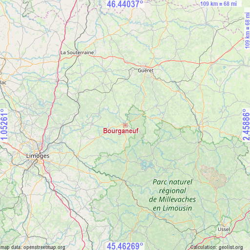
Bourganeuf GPS coordinates[2]
45° 57' 13.284" North, 1° 45' 20.664" East
| Map corner | latitude | longitude |
|---|---|---|
| Upper-left | 46.44037°, | 1.05261° |
| Center: | 45.95369°, | 1.75574° |
| Lower-right: | 45.46269°, | 2.45886° |
| Map W x H: | 108.7×108.7 km | = 67.5×67.5mi |
| max Lat: | 51.07786° ⇑66.8% North |
| Bourganeuf: | 45.95369° |
| min Lat: | ⇓33.2% South 41.3874° |
| min Long | Bourganeuf | max Long |
| -5.08615° | 1.75574° | 9.52242° |
| W 40.1%⇐ | ⇒59.9% E |
Elevation
Elevation of Bourganeuf is 460 m = 1509 ft, and this is 266.3 m = 874 ft above average elevation for this country.
| Max E: |
2333 m = 7654 ft | 8.6% |
| Bourganeuf | 460 m 1509 ft | |
| Avg. | 193.7 m = 635 ft | |
Min E: |
-1 m = -3 ft | 91.4% |
See also: France elevation on elevation.city.
Geographical zone
Bourganeuf is located in North temperate zone (between Tropic of Cancer and the Arctic Circle). Distance of this North polar circle is 2291.6 km =1423.9 mi to North.| Distance of | km | miles | from Bourganeuf |
|---|---|---|---|
| North Pole | 4897.5 | 3043.2 | to North |
| Arctic Circle | 2291.6 | 1423.9 | to North |
| Tropic Cancer | 2503.7 | 1555.7 | to South |
| Equator | 5109.6 | 3175 | to South |


Nearby cities:
15 places around Bourganeuf: (largest is in red/bold)
• Bujaleuf
20 km =12.4 mi,  209°
209°
• Bénévent-l’Abbaye
20.8 km =12.9 mi,  331°
331°
• Champnétery
19.6 km =12.2 mi,  226°
226°
• Eymoutiers
23.9 km =14.9 mi,  182°
182°
• La Jonchère-Saint-Maurice
22.8 km =14.2 mi,  282°
282°
• La Saunière
24.1 km =15 mi,  35°
35°
• Marsac
20.7 km =12.9 mi,  320°
320°
• Mourioux-Vieilleville
16.6 km =10.3 mi, 330°
• Peyrat-le-Château
15.6 km =9.7 mi, 175°
• Royère-de-Vassivière
18.3 km =11.4 mi,  137°
137°
• Saint-Dizier-Leyrenne
9.1 km =5.7 mi,  338°
338°
• Saint-Laurent-les-Églises
19.9 km =12.4 mi,  268°
268°
• Sainte-Feyre
24 km =14.9 mi,  30°
30°
• Sardent
13.3 km =8.3 mi, 35°
• Sauviat-sur-Vige
12.6 km =7.8 mi,  245°
245°
Sources, notices
• [Note1] Compared only with cities in France existing in our database
• [Src1] Map data: © OpenStreetMap contributors (CC-BY-SA)
• [Src2] Other city data from geonames.org with taken over terms of usage.
• [Src3] Geographical zone / Annual Mean Temperature by Robert A. Rohde @ Wikipedia
