La Jonchère-Saint-Maurice geodata
La Jonchère-Saint-Maurice (Nouvelle-Aquitaine) is a populated place; located in France in Europe/Paris (GMT+2) time zone. With population of 802 people, there are 10583 cities with bigger population in this country. Compared to other cities in France, 66.2% of cities are located further ↑North; 63.4% of cities are located further →East and 89.2% of cities have lower elevation than La Jonchère-Saint-Maurice. Note1
Administrative division(s):
- Level 1: Nouvelle-Aquitaine
- Level 2: Haute-Vienne
- Level 3: Arrondissement de Limoges
- Level 4: La Jonchère-Saint-Maurice
Current local time in La Jonchère-Saint-Maurice:
08:42 AM, SaturdayDifference from your time zone: hours


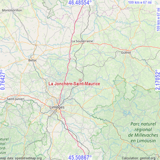
La Jonchère-Saint-Maurice GPS coordinates[2]
45° 59' 57.336" North, 1° 28' 2.64" East
| Map corner | latitude | longitude |
|---|---|---|
| Upper-left | 46.48554°, | 0.76427° |
| Center: | 45.99926°, | 1.4674° |
| Lower-right: | 45.50867°, | 2.17052° |
| Map W x H: | 108.6×108.6 km | = 67.5×67.5mi |
| max Lat: | 51.07786° ⇑66.2% North |
| La Jonchère-Saint-Maurice: | 45.99926° |
| min Lat: | ⇓33.8% South 41.3874° |
| min Long | La Jonchère-Sa | max Long |
| -5.08615° | 1.4674° | 9.52242° |
| W 36.6%⇐ | ⇒63.4% E |
Elevation
Elevation of La Jonchère-Saint-Maurice is 410 m = 1345 ft, and this is 216.3 m = 710 ft above average elevation for this country.
| Max E: |
2333 m = 7654 ft | 10.8% |
| La Jonchère-Saint-Maurice | 410 m 1345 ft | |
| Avg. | 193.7 m = 635 ft | |
Min E: |
-1 m = -3 ft | 89.2% |
See also: France elevation on elevation.city.
Geographical zone
La Jonchère-Saint-Maurice is located in North temperate zone (between Tropic of Cancer and the Arctic Circle). Distance of this North polar circle is 2286.5 km =1420.8 mi to North.| Distance of | km | miles | from La Jonchère-Saint-Maurice |
|---|---|---|---|
| North Pole | 4892.4 | 3040 | to North |
| Arctic Circle | 2286.5 | 1420.8 | to North |
| Tropic Cancer | 2508.7 | 1558.8 | to South |
| Equator | 5114.6 | 3178.1 | to South |


Nearby cities:
15 places around La Jonchère-Saint-Maurice: (largest is in red/bold)
• Ambazac
7 km =4.3 mi,  228°
228°
• Bersac-sur-Rivalier
9.6 km =6 mi,  340°
340°
• Bessines-sur-Gartempe
14.4 km =8.9 mi,  327°
327°
• Bonnac-la-Côte
15.5 km =9.6 mi,  245°
245°
• Compreignac
14.9 km =9.3 mi,  266°
266°
• Folles
12.9 km =8 mi,  357°
357°
• Laurière
8.6 km =5.3 mi,  4°
4°
• Marsac
14.3 km =8.9 mi,  39°
39°
• Razès
10.2 km =6.3 mi,  291°
291°
• Royères
16 km =9.9 mi,  188°
188°
• Saint-Laurent-les-Églises
6 km =3.7 mi,  156°
156°
• Saint-Priest-Taurion
13.6 km =8.5 mi,  202°
202°
• Saint-Sulpice-Laurière
6 km =3.7 mi, 2°
• Saint-Sylvestre
7 km =4.3 mi, 266°
• Sauviat-sur-Vige
14.9 km =9.3 mi,  133°
133°
Sources, notices
• [Note1] Compared only with cities in France existing in our database
• [Src1] Map data: © OpenStreetMap contributors (CC-BY-SA)
• [Src2] Other city data from geonames.org with taken over terms of usage.
• [Src3] Geographical zone / Annual Mean Temperature by Robert A. Rohde @ Wikipedia
