Fauguerolles geodata
Fauguerolles (Nouvelle-Aquitaine) is a populated place; located in France in Europe/Paris (GMT+2) time zone. With population of 595 people, there are 13406 cities with bigger population in this country. Compared to other cities in France, 84% of cities are located further ↑North; 75.8% of cities are located further →East and 88.6% of cities have higher elevation than Fauguerolles. Note1
Administrative division(s):
- Level 1: Nouvelle-Aquitaine
- Level 2: Département du Lot-et-Garonne
- Level 3: Arrondissement de Marmande
- Level 4: Fauguerolles


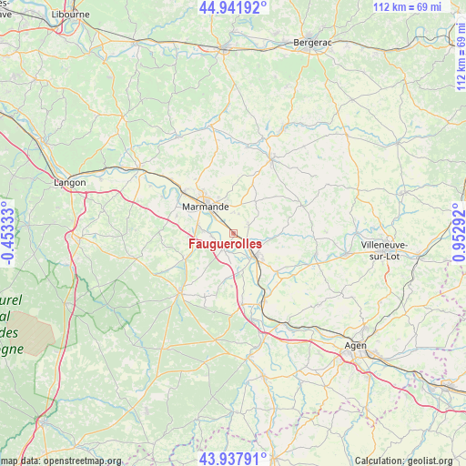
Fauguerolles GPS coordinates[2]
44° 26' 31.452" North, 0° 14' 59.244" East
| Map corner | latitude | longitude |
|---|---|---|
| Upper-left | 44.94192°, | -0.45333° |
| Center: | 44.44207°, | 0.24979° |
| Lower-right: | 43.93791°, | 0.95292° |
| Map W x H: | 111.6×111.6 km | = 69.3×69.3mi |
| max Lat: | 51.07786° ⇑84% North |
| Fauguerolles: | 44.44207° |
| min Lat: | ⇓16% South 41.3874° |
| min Long | Fauguerolles | max Long |
| -5.08615° | 0.24979° | 9.52242° |
| W 24.2%⇐ | ⇒75.8% E |
Elevation
Elevation of Fauguerolles is 33 m = 108 ft, and this is 160.7 m = 527 ft below average elevation for this country.
| Max E: |
2333 m = 7654 ft | 88.6% |
| Avg. | 193.7 m = 635 ft | |
| Fauguerolles | 33 m = 108 ft | |
Min E: |
-1 m = -3 ft | 11.4% |
See also: France elevation on elevation.city.
Geographical zone
Fauguerolles is located in North temperate zone (between Tropic of Cancer and the Arctic Circle). Distance of this Northern Tropic circle is 2335.6 km =1451.3 mi to South.| Distance of | km | miles | from Fauguerolles |
|---|---|---|---|
| North Pole | 5065.6 | 3147.6 | to North |
| Arctic Circle | 2459.7 | 1528.4 | to North |
| Tropic Cancer | 2335.6 | 1451.3 | to South |
| Equator | 4941.5 | 3070.5 | to South |


Nearby cities:
15 places around Fauguerolles: (largest is in red/bold)
• Birac-sur-Trec
5 km =3.1 mi,  15°
15°
• Calonges
7.6 km =4.7 mi,  184°
184°
• Caumont-sur-Garonne
5.4 km =3.4 mi,  264°
264°
• Fauillet
3.7 km =2.3 mi,  118°
118°
• Fourques-sur-Garonne
7.4 km =4.6 mi,  275°
275°
• Gontaud-de-Nogaret
4.1 km =2.5 mi,  77°
77°
• Le Mas-d’Agenais
4.3 km =2.7 mi,  214°
214°
• Marmande
9.3 km =5.8 mi,  313°
313°
• Puymiclan
9.4 km =5.8 mi,  33°
33°
• Saint-Pardoux-du-Breuil
5.8 km =3.6 mi, 310°
• Samazan
10.9 km =6.8 mi,  265°
265°
• Tonneins
7.5 km =4.7 mi,  138°
138°
• Varès
8.8 km =5.5 mi,  99°
99°
• Villeton
8.1 km =5 mi,  157°
157°
• Virazeil
7.6 km =4.7 mi,  342°
342°
Sources, notices
• [Note1] Compared only with cities in France existing in our database
• [Src1] Map data: © OpenStreetMap contributors (CC-BY-SA)
• [Src2] Other city data from geonames.org with taken over terms of usage.
• [Src3] Geographical zone / Annual Mean Temperature by Robert A. Rohde @ Wikipedia
