Bougligny geodata
Bougligny (Île-de-France) is a populated place; located in France in Europe/Paris (GMT+2) time zone. With population of 707 people, there are 11704 cities with bigger population in this country. Compared to other cities in France, 62.8% of cities are located further ↓South; 52.8% of cities are located further ←West and 54.8% of cities have higher elevation than Bougligny. Note1
Administrative division(s):
- Level 1: Île-de-France
- Level 2: Seine-et-Marne
- Level 3: Arrondissement de Fontainebleau
- Level 4: Bougligny


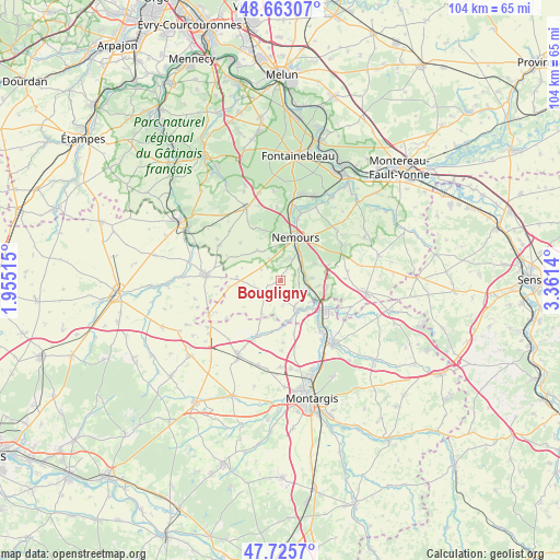
Bougligny GPS coordinates[2]
48° 11' 47.508" North, 2° 39' 29.808" East
| Map corner | latitude | longitude |
|---|---|---|
| Upper-left | 48.66307°, | 1.95515° |
| Center: | 48.19653°, | 2.65828° |
| Lower-right: | 47.7257°, | 3.3614° |
| Map W x H: | 104.2×104.2 km | = 64.7×64.7mi |
| max Lat: | 51.07786° ⇑37.2% North |
| Bougligny: | 48.19653° |
| min Lat: | ⇓62.8% South 41.3874° |
| min Long | Bougligny | max Long |
| -5.08615° | 2.65828° | 9.52242° |
| W 52.8%⇐ | ⇒47.2% E |
Elevation
Elevation of Bougligny is 117 m = 384 ft, and this is 76.7 m = 252 ft below average elevation for this country.
| Max E: |
2333 m = 7654 ft | 54.8% |
| Avg. | 193.7 m = 635 ft | |
| Bougligny | 117 m = 384 ft | |
Min E: |
-1 m = -3 ft | 45.2% |
See also: France elevation on elevation.city.
Geographical zone
Bougligny is located in North temperate zone (between Tropic of Cancer and the Arctic Circle). Distance of this North polar circle is 2042.2 km =1269 mi to North.| Distance of | km | miles | from Bougligny |
|---|---|---|---|
| North Pole | 4648.1 | 2888.2 | to North |
| Arctic Circle | 2042.2 | 1269 | to North |
| Tropic Cancer | 2753 | 1710.6 | to South |
| Equator | 5359 | 3329.9 | to South |


Nearby cities:
15 places around Bougligny: (largest is in red/bold)
• Bagneaux-sur-Loing
5.4 km =3.4 mi,  41°
41°
• Chaintreaux
12 km =7.5 mi,  88°
88°
• Château-Landon
6.2 km =3.9 mi,  152°
152°
• Darvault
9.7 km =6 mi,  33°
33°
• Dordives
10.1 km =6.3 mi,  126°
126°
• Fontenay-sur-Loing
13.5 km =8.4 mi,  139°
139°
• Larchant
10.9 km =6.8 mi,  334°
334°
• Montcourt-Fromonville
12.7 km =7.9 mi,  15°
15°
• Nanteau-sur-Lunain
13.2 km =8.2 mi,  59°
59°
• Nargis
12 km =7.5 mi, 142°
• Nemours
9.1 km =5.7 mi, 15°
• Poligny
7.1 km =4.4 mi, 64°
• Saint-Pierre-lès-Nemours
8 km =5 mi,  11°
11°
• Sceaux-du-Gâtinais
11.1 km =6.9 mi,  204°
204°
• Souppes-sur-Loing
5.9 km =3.7 mi,  104°
104°
Sources, notices
• [Note1] Compared only with cities in France existing in our database
• [Src1] Map data: © OpenStreetMap contributors (CC-BY-SA)
• [Src2] Other city data from geonames.org with taken over terms of usage.
• [Src3] Geographical zone / Annual Mean Temperature by Robert A. Rohde @ Wikipedia
