Bouafle geodata
Bouafle (Île-de-France) is a populated place; located in France in Europe/Paris (GMT+2) time zone. With population of 2,115 people, there are 4552 cities with bigger population in this country. Compared to other cities in France, 78.9% of cities are located further ↓South; 58.3% of cities are located further →East and 74.1% of cities have higher elevation than Bouafle. Note1
Administrative division(s):
- Level 1: Île-de-France
- Level 2: Yvelines
- Level 3: Arrondissement de Mantes-la-Jolie
- Level 4: Bouafle


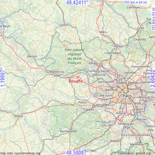
Bouafle GPS coordinates[2]
48° 57' 52.668" North, 1° 54' 4.32" East
| Map corner | latitude | longitude |
|---|---|---|
| Upper-left | 49.42411°, | 1.19807° |
| Center: | 48.96463°, | 1.9012° |
| Lower-right: | 48.50087°, | 2.60432° |
| Map W x H: | 102.7×102.7 km | = 63.8×63.8mi |
| max Lat: | 51.07786° ⇑21.1% North |
| Bouafle: | 48.96463° |
| min Lat: | ⇓78.9% South 41.3874° |
| min Long | Bouafle | max Long |
| -5.08615° | 1.9012° | 9.52242° |
| W 41.7%⇐ | ⇒58.3% E |
Elevation
Elevation of Bouafle is 69 m = 226 ft, and this is 124.7 m = 409 ft below average elevation for this country.
| Max E: |
2333 m = 7654 ft | 74.1% |
| Avg. | 193.7 m = 635 ft | |
| Bouafle | 69 m = 226 ft | |
Min E: |
-1 m = -3 ft | 25.9% |
See also: France elevation on elevation.city.
Geographical zone
Bouafle is located in North temperate zone (between Tropic of Cancer and the Arctic Circle). Distance of this North polar circle is 1956.8 km =1215.9 mi to North.| Distance of | km | miles | from Bouafle |
|---|---|---|---|
| North Pole | 4562.7 | 2835.1 | to North |
| Arctic Circle | 1956.8 | 1215.9 | to North |
| Tropic Cancer | 2838.4 | 1763.7 | to South |
| Equator | 5444.4 | 3383 | to South |


Nearby cities:
15 places around Bouafle: (largest is in red/bold)
• Aubergenville
3.4 km =2.1 mi,  261°
261°
• Bazemont
4.9 km =3 mi,  211°
211°
• Chapet
2.4 km =1.5 mi,  84°
84°
• Ecquevilly
2.1 km =1.3 mi,  131°
131°
• Flins-sur-Seine
2 km =1.2 mi,  271°
271°
• Hardricourt
4.8 km =3 mi,  353°
353°
• Juziers
4.9 km =3 mi,  307°
307°
• La Falaise
5.7 km =3.5 mi,  245°
245°
• Les Alluets-le-Roi
5.8 km =3.6 mi,  167°
167°
• Les Mureaux
3.1 km =1.9 mi,  11°
11°
• Meulan-en-Yvelines
4.8 km =3 mi,  4°
4°
• Morainvilliers
4.7 km =2.9 mi,  147°
147°
• Mézy-sur-Seine
4.1 km =2.5 mi,  341°
341°
• Nézel
5.1 km =3.2 mi,  243°
243°
• Verneuil-sur-Seine
4.8 km =3 mi, 77°
Sources, notices
• [Note1] Compared only with cities in France existing in our database
• [Src1] Map data: © OpenStreetMap contributors (CC-BY-SA)
• [Src2] Other city data from geonames.org with taken over terms of usage.
• [Src3] Geographical zone / Annual Mean Temperature by Robert A. Rohde @ Wikipedia
