Sainte-Marie-Cappel geodata
Sainte-Marie-Cappel (Hauts-de-France) is a populated place; located in France in Europe/Paris (GMT+2) time zone. With population of 704 people, there are 11748 cities with bigger population in this country. Compared to other cities in France, 99.2% of cities are located further ↓South; 50.7% of cities are located further ←West and 79.4% of cities have higher elevation than Sainte-Marie-Cappel. Note1
Administrative division(s):
- Level 1: Hauts-de-France
- Level 2: Nord
- Level 3: Arrondissement de Dunkerque
- Level 4: Sainte-Marie-Cappel


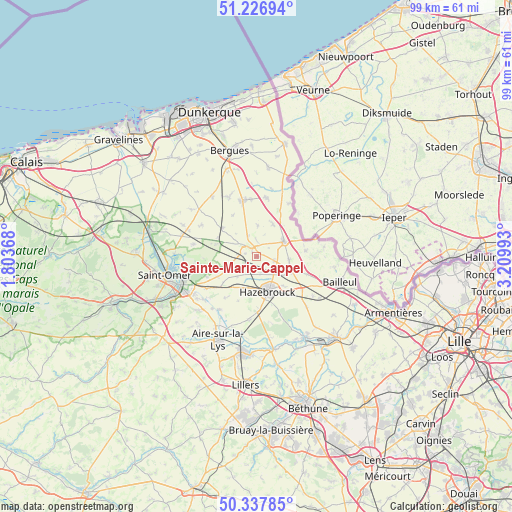
Sainte-Marie-Cappel GPS coordinates[2]
50° 47' 4.236" North, 2° 30' 24.48" East
| Map corner | latitude | longitude |
|---|---|---|
| Upper-left | 51.22694°, | 1.80368° |
| Center: | 50.78451°, | 2.5068° |
| Lower-right: | 50.33785°, | 3.20993° |
| Map W x H: | 98.9×98.9 km | = 61.5×61.5mi |
| max Lat: | 51.07786° ⇑0.8% North |
| Sainte-Marie-Cappel: | 50.78451° |
| min Lat: | ⇓99.2% South 41.3874° |
| min Long | Sainte-Marie-Ca | max Long |
| -5.08615° | 2.5068° | 9.52242° |
| W 50.7%⇐ | ⇒49.3% E |
Elevation
Elevation of Sainte-Marie-Cappel is 56 m = 184 ft, and this is 137.7 m = 452 ft below average elevation for this country.
| Max E: |
2333 m = 7654 ft | 79.4% |
| Avg. | 193.7 m = 635 ft | |
| Sainte-Marie-Cappel | 56 m = 184 ft | |
Min E: |
-1 m = -3 ft | 20.6% |
See also: France elevation on elevation.city.
Geographical zone
Sainte-Marie-Cappel is located in North temperate zone (between Tropic of Cancer and the Arctic Circle). Distance of this North polar circle is 1754.5 km =1090.2 mi to North.| Distance of | km | miles | from Sainte-Marie-Cappel |
|---|---|---|---|
| North Pole | 4360.4 | 2709.4 | to North |
| Arctic Circle | 1754.5 | 1090.2 | to North |
| Tropic Cancer | 3040.8 | 1889.5 | to South |
| Equator | 5646.7 | 3508.7 | to South |


Nearby cities:
15 places around Sainte-Marie-Cappel: (largest is in red/bold)
• Bavinchove
3.5 km =2.2 mi,  273°
273°
• Borre
8.1 km =5 mi,  137°
137°
• Cassel
2.4 km =1.5 mi,  320°
320°
• Caëstre
7.3 km =4.5 mi,  113°
113°
• Eecke
6.3 km =3.9 mi,  95°
95°
• Hazebrouck
7.1 km =4.4 mi,  162°
162°
• Hondeghem
3.3 km =2.1 mi, 162°
• Noordpeene
7.9 km =4.9 mi,  288°
288°
• Oudezeele
6 km =3.7 mi,  2°
2°
• Saint-Sylvestre-Cappel
3.6 km =2.2 mi, 104°
• Staple
5.4 km =3.4 mi,  223°
223°
• Steenvoorde
6 km =3.7 mi,  61°
61°
• Terdeghem
2.8 km =1.7 mi, 55°
• Wallon-Cappel
6.8 km =4.2 mi,  199°
199°
• Winnezeele
7 km =4.3 mi,  26°
26°
Sources, notices
• [Note1] Compared only with cities in France existing in our database
• [Src1] Map data: © OpenStreetMap contributors (CC-BY-SA)
• [Src2] Other city data from geonames.org with taken over terms of usage.
• [Src3] Geographical zone / Annual Mean Temperature by Robert A. Rohde @ Wikipedia
