Terdeghem geodata
Terdeghem (Hauts-de-France) is a populated place; located in France in Europe/Paris (GMT+2) time zone. With population of 559 people, there are 14019 cities with bigger population in this country. Compared to other cities in France, 99.3% of cities are located further ↓South; 51.2% of cities are located further ←West and 88.6% of cities have higher elevation than Terdeghem. Note1
Administrative division(s):
- Level 1: Hauts-de-France
- Level 2: Nord
- Level 3: Arrondissement de Dunkerque
- Level 4: Terdeghem


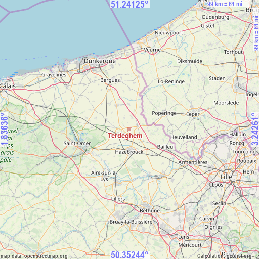
Terdeghem GPS coordinates[2]
50° 47' 56.256" North, 2° 32' 22.164" East
| Map corner | latitude | longitude |
|---|---|---|
| Upper-left | 51.24125°, | 1.83636° |
| Center: | 50.79896°, | 2.53949° |
| Lower-right: | 50.35244°, | 3.24261° |
| Map W x H: | 98.8×98.8 km | = 61.4×61.4mi |
| max Lat: | 51.07786° ⇑0.7% North |
| Terdeghem: | 50.79896° |
| min Lat: | ⇓99.3% South 41.3874° |
| min Long | Terdeghem | max Long |
| -5.08615° | 2.53949° | 9.52242° |
| W 51.2%⇐ | ⇒48.8% E |
Elevation
Elevation of Terdeghem is 33 m = 108 ft, and this is 160.7 m = 527 ft below average elevation for this country.
| Max E: |
2333 m = 7654 ft | 88.6% |
| Avg. | 193.7 m = 635 ft | |
| Terdeghem | 33 m = 108 ft | |
Min E: |
-1 m = -3 ft | 11.4% |
See also: France elevation on elevation.city.
Geographical zone
Terdeghem is located in North temperate zone (between Tropic of Cancer and the Arctic Circle). Distance of this North polar circle is 1752.9 km =1089.2 mi to North.| Distance of | km | miles | from Terdeghem |
|---|---|---|---|
| North Pole | 4358.7 | 2708.4 | to North |
| Arctic Circle | 1752.9 | 1089.2 | to North |
| Tropic Cancer | 3042.4 | 1890.5 | to South |
| Equator | 5648.3 | 3509.7 | to South |


Nearby cities:
15 places around Terdeghem: (largest is in red/bold)
• Bavinchove
6 km =3.7 mi,  256°
256°
• Borre
8.2 km =5.1 mi,  157°
157°
• Cassel
3.8 km =2.4 mi,  273°
273°
• Caëstre
6.3 km =3.9 mi,  135°
135°
• Eecke
4.6 km =2.9 mi,  119°
119°
• Flêtre
8.9 km =5.5 mi, 123°
• Godewaersvelde
7.4 km =4.6 mi,  94°
94°
• Hazebrouck
8.4 km =5.2 mi,  181°
181°
• Hondeghem
4.9 km =3 mi,  195°
195°
• Oudezeele
4.8 km =3 mi,  334°
334°
• Saint-Sylvestre-Cappel
2.8 km =1.7 mi, 155°
• Sainte-Marie-Cappel
2.8 km =1.7 mi,  235°
235°
• Staple
8.2 km =5.1 mi,  227°
227°
• Steenvoorde
3.3 km =2.1 mi,  67°
67°
• Winnezeele
4.7 km =2.9 mi,  9°
9°
Sources, notices
• [Note1] Compared only with cities in France existing in our database
• [Src1] Map data: © OpenStreetMap contributors (CC-BY-SA)
• [Src2] Other city data from geonames.org with taken over terms of usage.
• [Src3] Geographical zone / Annual Mean Temperature by Robert A. Rohde @ Wikipedia
