Saint-Sylvestre-Cappel geodata
Saint-Sylvestre-Cappel (Hauts-de-France) is a populated place; located in France in Europe/Paris (GMT+2) time zone. With population of 1,107 people, there are 8081 cities with bigger population in this country. Compared to other cities in France, 99.2% of cities are located further ↓South; 51.5% of cities are located further ←West and 82.2% of cities have higher elevation than Saint-Sylvestre-Cappel. Note1
Administrative division(s):
- Level 1: Hauts-de-France
- Level 2: Nord
- Level 3: Arrondissement de Dunkerque
- Level 4: Saint-Sylvestre-Cappel
Current local time in Saint-Sylvestre-Cappel:
01:20 AM, SaturdayDifference from your time zone: hours


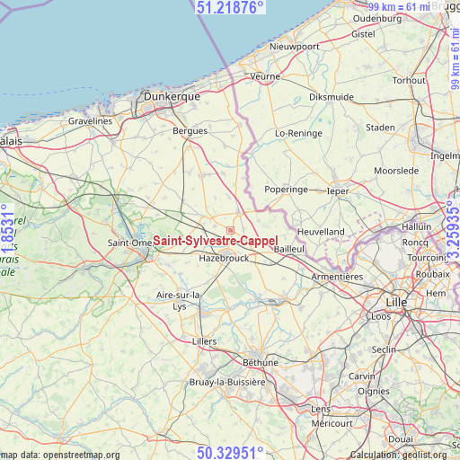
Saint-Sylvestre-Cappel GPS coordinates[2]
50° 46' 34.5" North, 2° 33' 22.392" East
| Map corner | latitude | longitude |
|---|---|---|
| Upper-left | 51.21876°, | 1.8531° |
| Center: | 50.77625°, | 2.55622° |
| Lower-right: | 50.32951°, | 3.25935° |
| Map W x H: | 98.9×98.9 km | = 61.5×61.5mi |
| max Lat: | 51.07786° ⇑0.8% North |
| Saint-Sylvestre-Cappel: | 50.77625° |
| min Lat: | ⇓99.2% South 41.3874° |
| min Long | Saint-Sylvestre | max Long |
| -5.08615° | 2.55622° | 9.52242° |
| W 51.5%⇐ | ⇒48.5% E |
Elevation
Elevation of Saint-Sylvestre-Cappel is 49 m = 161 ft, and this is 144.7 m = 475 ft below average elevation for this country.
| Max E: |
2333 m = 7654 ft | 82.2% |
| Avg. | 193.7 m = 635 ft | |
| Saint-Sylvestre-Cappel | 49 m = 161 ft | |
Min E: |
-1 m = -3 ft | 17.8% |
See also: France elevation on elevation.city.
Geographical zone
Saint-Sylvestre-Cappel is located in North temperate zone (between Tropic of Cancer and the Arctic Circle). Distance of this North polar circle is 1755.4 km =1090.8 mi to North.| Distance of | km | miles | from Saint-Sylvestre-Cappel |
|---|---|---|---|
| North Pole | 4361.3 | 2710 | to North |
| Arctic Circle | 1755.4 | 1090.8 | to North |
| Tropic Cancer | 3039.9 | 1888.9 | to South |
| Equator | 5645.8 | 3508.1 | to South |


Nearby cities:
15 places around Saint-Sylvestre-Cappel: (largest is in red/bold)
• Bavinchove
7.1 km =4.4 mi,  278°
278°
• Borre
5.4 km =3.4 mi,  158°
158°
• Cassel
5.7 km =3.5 mi,  298°
298°
• Caëstre
3.8 km =2.4 mi,  121°
121°
• Eecke
2.8 km =1.7 mi,  84°
84°
• Flêtre
6.7 km =4.2 mi,  110°
110°
• Godewaersvelde
6.5 km =4 mi,  72°
72°
• Hazebrouck
6 km =3.7 mi,  192°
192°
• Hondeghem
3.3 km =2.1 mi,  228°
228°
• Oudezeele
7.6 km =4.7 mi,  334°
334°
• Sainte-Marie-Cappel
3.6 km =2.2 mi, 284°
• Steenvoorde
4.2 km =2.6 mi,  25°
25°
• Strazeele
7.6 km =4.7 mi,  136°
136°
• Terdeghem
2.8 km =1.7 mi,  335°
335°
• Winnezeele
7.2 km =4.5 mi,  357°
357°
Sources, notices
• [Note1] Compared only with cities in France existing in our database
• [Src1] Map data: © OpenStreetMap contributors (CC-BY-SA)
• [Src2] Other city data from geonames.org with taken over terms of usage.
• [Src3] Geographical zone / Annual Mean Temperature by Robert A. Rohde @ Wikipedia
