Chambles geodata
Chambles (Auvergne-Rhône-Alpes) is a populated place; located in France in Europe/Paris (GMT+2) time zone. With population of 777 people, there are 10851 cities with bigger population in this country. Compared to other cities in France, 74.7% of cities are located further ↑North; 70% of cities are located further ←West and 94.8% of cities have lower elevation than Chambles. Note1
Administrative division(s):
- Level 1: Auvergne-Rhône-Alpes
- Level 2: Département de la Loire
- Level 3: Arrondissement de Montbrison
- Level 4: Chambles


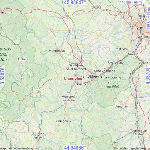
Chambles GPS coordinates[2]
45° 26' 43.152" North, 4° 14' 2.04" East
| Map corner | latitude | longitude |
|---|---|---|
| Upper-left | 45.93647°, | 3.53078° |
| Center: | 45.44532°, | 4.2339° |
| Lower-right: | 44.94986°, | 4.93703° |
| Map W x H: | 109.7×109.7 km | = 68.2×68.2mi |
| max Lat: | 51.07786° ⇑74.7% North |
| Chambles: | 45.44532° |
| min Lat: | ⇓25.3% South 41.3874° |
| min Long | Chambles | max Long |
| -5.08615° | 4.2339° | 9.52242° |
| W 70%⇐ | ⇒30% E |
Elevation
Elevation of Chambles is 571 m = 1873 ft, and this is 377.3 m = 1238 ft above average elevation for this country.
| Max E: |
2333 m = 7654 ft | 5.2% |
| Chambles | 571 m 1873 ft | |
| Avg. | 193.7 m = 635 ft | |
Min E: |
-1 m = -3 ft | 94.8% |
See also: France elevation on elevation.city.
Geographical zone
Chambles is located in North temperate zone (between Tropic of Cancer and the Arctic Circle). Distance of this North polar circle is 2348.1 km =1459 mi to North.| Distance of | km | miles | from Chambles |
|---|---|---|---|
| North Pole | 4954 | 3078.3 | to North |
| Arctic Circle | 2348.1 | 1459 | to North |
| Tropic Cancer | 2447.1 | 1520.6 | to South |
| Equator | 5053 | 3139.8 | to South |


Nearby cities:
15 places around Chambles: (largest is in red/bold)
• Andrézieux-Bouthéon
9.2 km =5.7 mi,  12°
12°
• Aurec-sur-Loire
8.8 km =5.5 mi,  196°
196°
• Bonson
8.8 km =5.5 mi,  349°
349°
• Firminy
7.5 km =4.7 mi,  145°
145°
• Fraisses
6.7 km =4.2 mi,  159°
159°
• La Fouillouse
9.1 km =5.7 mi,  43°
43°
• Le Chambon-Feugerolles
9.1 km =5.7 mi,  131°
131°
• Périgneux
6.1 km =3.8 mi,  265°
265°
• Roche-la-Molière
7.5 km =4.7 mi,  102°
102°
• Saint-Genest-Lerpt
8.3 km =5.2 mi,  91°
91°
• Saint-Just-Saint-Rambert
6.1 km =3.8 mi, 5°
• Saint-Marcellin-en-Forez
7.5 km =4.7 mi,  319°
319°
• Saint-Maurice-en-Gourgois
6.3 km =3.9 mi,  219°
219°
• Saint-Paul
5.3 km =3.3 mi,  186°
186°
• Unieux
5.4 km =3.4 mi, 147°
Sources, notices
• [Note1] Compared only with cities in France existing in our database
• [Src1] Map data: © OpenStreetMap contributors (CC-BY-SA)
• [Src2] Other city data from geonames.org with taken over terms of usage.
• [Src3] Geographical zone / Annual Mean Temperature by Robert A. Rohde @ Wikipedia
