Andrézieux-Bouthéon geodata
Andrézieux-Bouthéon (Auvergne-Rhône-Alpes) is a populated place; located in France in Europe/Paris (GMT+2) time zone. With population of 9,452 people, there are 1014 cities with bigger population in this country. Compared to other cities in France, 73.8% of cities are located further ↑North; 70.2% of cities are located further ←West and 87.9% of cities have lower elevation than Andrézieux-Bouthéon. Note1
Administrative division(s):
- Level 1: Auvergne-Rhône-Alpes
- Level 2: Département de la Loire
- Level 3: Arrondissement de Saint-Étienne
- Level 4: Andrézieux-Bouthéon


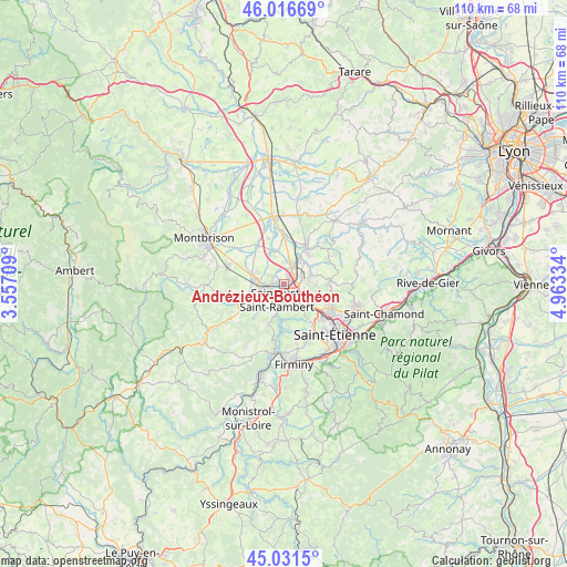
Andrézieux-Bouthéon GPS coordinates[2]
45° 31' 34.5" North, 4° 15' 36.756" East
| Map corner | latitude | longitude |
|---|---|---|
| Upper-left | 46.01669°, | 3.55709° |
| Center: | 45.52625°, | 4.26021° |
| Lower-right: | 45.0315°, | 4.96334° |
| Map W x H: | 109.5×109.5 km | = 68×68mi |
| max Lat: | 51.07786° ⇑73.8% North |
| Andrézieux-Bouthéon: | 45.52625° |
| min Lat: | ⇓26.2% South 41.3874° |
| min Long | Andrézieux-Bou | max Long |
| -5.08615° | 4.26021° | 9.52242° |
| W 70.2%⇐ | ⇒29.8% E |
Elevation
Elevation of Andrézieux-Bouthéon is 387 m = 1270 ft, and this is 193.3 m = 634 ft above average elevation for this country.
| Max E: |
2333 m = 7654 ft | 12.1% |
| Andrézieux-Bouthéon | 387 m 1270 ft | |
| Avg. | 193.7 m = 635 ft | |
Min E: |
-1 m = -3 ft | 87.9% |
See also: France elevation on elevation.city.
Geographical zone
Andrézieux-Bouthéon is located in North temperate zone (between Tropic of Cancer and the Arctic Circle). Distance of this North polar circle is 2339.1 km =1453.4 mi to North.| Distance of | km | miles | from Andrézieux-Bouthéon |
|---|---|---|---|
| North Pole | 4945 | 3072.7 | to North |
| Arctic Circle | 2339.1 | 1453.4 | to North |
| Tropic Cancer | 2456.1 | 1526.1 | to South |
| Equator | 5062 | 3145.4 | to South |


Nearby cities:
15 places around Andrézieux-Bouthéon: (largest is in red/bold)
• Bonson
3.7 km =2.3 mi,  264°
264°
• Chambles
9.2 km =5.7 mi,  192°
192°
• Chambœuf
7.7 km =4.8 mi,  34°
34°
• Craintilleux
6.7 km =4.2 mi,  338°
338°
• Cuzieu
9.1 km =5.7 mi,  358°
358°
• La Fouillouse
4.9 km =3 mi,  119°
119°
• Saint-Bonnet-les-Oules
5.7 km =3.5 mi,  62°
62°
• Saint-Cyprien
2.2 km =1.4 mi,  294°
294°
• Saint-Galmier
8.9 km =5.5 mi, 26°
• Saint-Héand
8.6 km =5.3 mi,  89°
89°
• Saint-Just-Saint-Rambert
3.3 km =2.1 mi,  206°
206°
• Saint-Marcellin-en-Forez
7.6 km =4.7 mi,  244°
244°
• Sury-le-Comtal
5.9 km =3.7 mi,  282°
282°
• Veauche
4.8 km =3 mi, 30°
• Veauchette
4 km =2.5 mi,  2°
2°
Sources, notices
• [Note1] Compared only with cities in France existing in our database
• [Src1] Map data: © OpenStreetMap contributors (CC-BY-SA)
• [Src2] Other city data from geonames.org with taken over terms of usage.
• [Src3] Geographical zone / Annual Mean Temperature by Robert A. Rohde @ Wikipedia
