Saint-Nazaire geodata
Saint-Nazaire (Occitanie) is a populated place; located in France in Europe/Paris (GMT+2) time zone. With population of 2,611 people, there are 3734 cities with bigger population in this country. Compared to other cities in France, 99.1% of cities are located further ↑North; 57.7% of cities are located further ←West and 97% of cities have higher elevation than Saint-Nazaire. Note1
Administrative division(s):
- Level 1: Occitanie
- Level 2: Département des Pyrénées-Orientales
- Level 3: Arrondissement de Perpignan
- Level 4: Saint-Nazaire


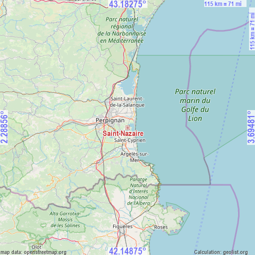
Saint-Nazaire GPS coordinates[2]
42° 40' 4.44" North, 2° 59' 30.048" East
| Map corner | latitude | longitude |
|---|---|---|
| Upper-left | 43.18275°, | 2.28856° |
| Center: | 42.6679°, | 2.99168° |
| Lower-right: | 42.14875°, | 3.69481° |
| Map W x H: | 115×115 km | = 71.5×71.5mi |
| max Lat: | 51.07786° ⇑99.1% North |
| Saint-Nazaire: | 42.6679° |
| min Lat: | ⇓0.9% South 41.3874° |
| min Long | Saint-Nazaire | max Long |
| -5.08615° | 2.99168° | 9.52242° |
| W 57.7%⇐ | ⇒42.3% E |
Elevation
Elevation of Saint-Nazaire is 11 m = 36 ft, and this is 182.7 m = 599 ft below average elevation for this country.
| Max E: |
2333 m = 7654 ft | 97% |
| Avg. | 193.7 m = 635 ft | |
| Saint-Nazaire | 11 m = 36 ft | |
Min E: |
-1 m = -3 ft | 3% |
See also: France elevation on elevation.city.
Geographical zone
Saint-Nazaire is located in North temperate zone (between Tropic of Cancer and the Arctic Circle). Distance of this Northern Tropic circle is 2138.3 km =1328.7 mi to South.| Distance of | km | miles | from Saint-Nazaire |
|---|---|---|---|
| North Pole | 5262.8 | 3270.2 | to North |
| Arctic Circle | 2656.9 | 1650.9 | to North |
| Tropic Cancer | 2138.3 | 1328.7 | to South |
| Equator | 4744.2 | 2947.9 | to South |


Nearby cities:
15 places around Saint-Nazaire: (largest is in red/bold)
• Alénya
3.3 km =2.1 mi,  194°
194°
• Bompas
8.7 km =5.4 mi,  326°
326°
• Cabestany
4.4 km =2.7 mi,  289°
289°
• Canet-en-Roussillon
4.1 km =2.5 mi,  29°
29°
• Corneilla-del-Vercol
5.9 km =3.7 mi,  213°
213°
• Elne
7.7 km =4.8 mi, 192°
• Latour-Bas-Elne
6.9 km =4.3 mi,  172°
172°
• Montescot
8.3 km =5.2 mi,  215°
215°
• Perpignan
8.5 km =5.3 mi, 292°
• Saint-Cyprien-Plage
5.2 km =3.2 mi,  139°
139°
• Sainte-Marie-Plage
7.4 km =4.6 mi, 30°
• Saleilles
3.5 km =2.2 mi,  244°
244°
• Théza
4.7 km =2.9 mi, 224°
• Villelongue-de-la-Salanque
6.5 km =4 mi,  353°
353°
• Villeneuve-de-la-Raho
7.1 km =4.4 mi, 239°
Sources, notices
• [Note1] Compared only with cities in France existing in our database
• [Src1] Map data: © OpenStreetMap contributors (CC-BY-SA)
• [Src2] Other city data from geonames.org with taken over terms of usage.
• [Src3] Geographical zone / Annual Mean Temperature by Robert A. Rohde @ Wikipedia
