Boissy-sans-Avoir geodata
Boissy-sans-Avoir (Île-de-France) is a populated place; located in France in Europe/Paris (GMT+2) time zone. With population of 545 people, there are 14306 cities with bigger population in this country. Compared to other cities in France, 75.9% of cities are located further ↓South; 59.4% of cities are located further →East and 63.2% of cities have higher elevation than Boissy-sans-Avoir. Note1
Administrative division(s):
- Level 1: Île-de-France
- Level 2: Yvelines
- Level 3: Arrondissement de Rambouillet
- Level 4: Boissy-sans-Avoir


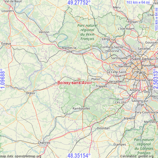
Boissy-sans-Avoir GPS coordinates[2]
48° 49' 0.012" North, 1° 48' 0" East
| Map corner | latitude | longitude |
|---|---|---|
| Upper-left | 49.27752°, | 1.09688° |
| Center: | 48.81667°, | 1.8° |
| Lower-right: | 48.35154°, | 2.50313° |
| Map W x H: | 103×103 km | = 64×64mi |
| max Lat: | 51.07786° ⇑24.1% North |
| Boissy-sans-Avoir: | 48.81667° |
| min Lat: | ⇓75.9% South 41.3874° |
| min Long | Boissy-sans-Avo | max Long |
| -5.08615° | 1.8° | 9.52242° |
| W 40.6%⇐ | ⇒59.4% E |
Elevation
Elevation of Boissy-sans-Avoir is 94 m = 308 ft, and this is 99.7 m = 327 ft below average elevation for this country.
| Max E: |
2333 m = 7654 ft | 63.2% |
| Avg. | 193.7 m = 635 ft | |
| Boissy-sans-Avoir | 94 m = 308 ft | |
Min E: |
-1 m = -3 ft | 36.8% |
See also: France elevation on elevation.city.
Geographical zone
Boissy-sans-Avoir is located in North temperate zone (between Tropic of Cancer and the Arctic Circle). Distance of this North polar circle is 1973.3 km =1226.2 mi to North.| Distance of | km | miles | from Boissy-sans-Avoir |
|---|---|---|---|
| North Pole | 4579.2 | 2845.4 | to North |
| Arctic Circle | 1973.3 | 1226.2 | to North |
| Tropic Cancer | 2822 | 1753.5 | to South |
| Equator | 5427.9 | 3372.7 | to South |


Nearby cities:
15 places around Boissy-sans-Avoir: (largest is in red/bold)
• Auteuil
3 km =1.9 mi,  25°
25°
• Bazoches-sur-Guyonne
5.9 km =3.7 mi,  136°
136°
• Beynes
6.9 km =4.3 mi,  50°
50°
• Flexanville
6.1 km =3.8 mi,  311°
311°
• Galluis
2.3 km =1.4 mi,  190°
190°
• Garancières
3.4 km =2.1 mi,  281°
281°
• Grosrouvre
4.8 km =3 mi,  216°
216°
• La Queue-les-Yvelines
3.1 km =1.9 mi,  232°
232°
• Marcq
5 km =3.1 mi,  21°
21°
• Méré
3.7 km =2.3 mi,  165°
165°
• Neauphle-le-Vieux
4.5 km =2.8 mi,  91°
91°
• Saulx-Marchais
3.6 km =2.2 mi, 49°
• Thoiry
5.6 km =3.5 mi,  358°
358°
• Villiers-Saint-Fréderic
6.1 km =3.8 mi, 90°
• Villiers-le-Mahieu
5.3 km =3.3 mi,  337°
337°
Sources, notices
• [Note1] Compared only with cities in France existing in our database
• [Src1] Map data: © OpenStreetMap contributors (CC-BY-SA)
• [Src2] Other city data from geonames.org with taken over terms of usage.
• [Src3] Geographical zone / Annual Mean Temperature by Robert A. Rohde @ Wikipedia
