Thoiry geodata
Thoiry (Île-de-France) is a populated place; located in France in Europe/Paris (GMT+2) time zone. With population of 1,015 people, there are 8732 cities with bigger population in this country. Compared to other cities in France, 77% of cities are located further ↓South; 59.4% of cities are located further →East and 53.6% of cities have lower elevation than Thoiry. Note1
Administrative division(s):
- Level 1: Île-de-France
- Level 2: Yvelines
- Level 3: Arrondissement de Rambouillet
- Level 4: Thoiry


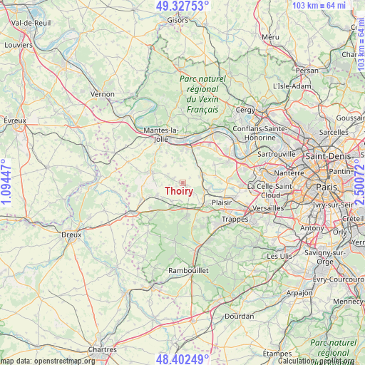
Thoiry GPS coordinates[2]
48° 52' 1.74" North, 1° 47' 51.36" East
| Map corner | latitude | longitude |
|---|---|---|
| Upper-left | 49.32753°, | 1.09447° |
| Center: | 48.86715°, | 1.7976° |
| Lower-right: | 48.40249°, | 2.50072° |
| Map W x H: | 102.9×102.9 km | = 63.9×63.9mi |
| max Lat: | 51.07786° ⇑23% North |
| Thoiry: | 48.86715° |
| min Lat: | ⇓77% South 41.3874° |
| min Long | Thoiry | max Long |
| -5.08615° | 1.7976° | 9.52242° |
| W 40.6%⇐ | ⇒59.4% E |
Elevation
Elevation of Thoiry is 145 m = 476 ft, and this is 48.7 m = 160 ft below average elevation for this country.
| Max E: |
2333 m = 7654 ft | 46.4% |
| Avg. | 193.7 m = 635 ft | |
| Thoiry | 145 m = 476 ft | |
Min E: |
-1 m = -3 ft | 53.6% |
See also: France elevation on elevation.city.
Geographical zone
Thoiry is located in North temperate zone (between Tropic of Cancer and the Arctic Circle). Distance of this North polar circle is 1967.7 km =1222.7 mi to North.| Distance of | km | miles | from Thoiry |
|---|---|---|---|
| North Pole | 4573.5 | 2841.8 | to North |
| Arctic Circle | 1967.7 | 1222.7 | to North |
| Tropic Cancer | 2827.6 | 1757 | to South |
| Equator | 5433.5 | 3376.2 | to South |


Nearby cities:
15 places around Thoiry: (largest is in red/bold)
• Arnouville-lès-Mantes
6.8 km =4.2 mi,  314°
314°
• Auteuil
3.3 km =2.1 mi,  153°
153°
• Beynes
5.6 km =3.5 mi,  102°
102°
• Boissy-sans-Avoir
5.6 km =3.5 mi,  178°
178°
• Flexanville
4.6 km =2.9 mi,  250°
250°
• Garancières
5.8 km =3.6 mi,  212°
212°
• Goussonville
6.4 km =4 mi,  337°
337°
• Jumeauville
4.9 km =3 mi,  351°
351°
• Marcq
2.2 km =1.4 mi,  115°
115°
• Mareil-sur-Mauldre
6.1 km =3.8 mi,  59°
59°
• Maule
6.3 km =3.9 mi,  39°
39°
• Montainville
4.9 km =3 mi,  69°
69°
• Neauphle-le-Vieux
7.4 km =4.6 mi,  140°
140°
• Saulx-Marchais
4.4 km =2.7 mi, 137°
• Villiers-le-Mahieu
2 km =1.2 mi, 249°
Sources, notices
• [Note1] Compared only with cities in France existing in our database
• [Src1] Map data: © OpenStreetMap contributors (CC-BY-SA)
• [Src2] Other city data from geonames.org with taken over terms of usage.
• [Src3] Geographical zone / Annual Mean Temperature by Robert A. Rohde @ Wikipedia
