Biguglia geodata
Biguglia (Corsica) is a populated place; located in France in Europe/Paris (GMT+2) time zone. With population of 5,552 people, there are 1784 cities with bigger population in this country. Compared to other cities in France, 99.2% of cities are located further ↑North; 99.8% of cities are located further ←West and 85.9% of cities have higher elevation than Biguglia. Note1
Administrative division(s):
- Level 1: Corsica
- Level 2: Département de la Haute-Corse
- Level 3: Arrondissement de Bastia
- Level 4: Biguglia


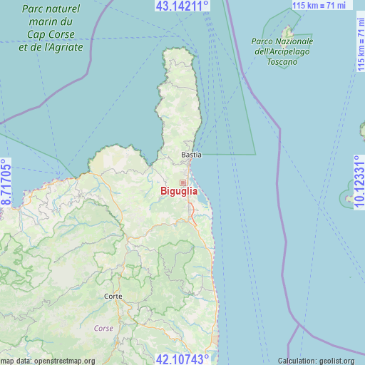
Biguglia GPS coordinates[2]
42° 37' 36.912" North, 9° 25' 12.648" East
| Map corner | latitude | longitude |
|---|---|---|
| Upper-left | 43.14211°, | 8.71705° |
| Center: | 42.62692°, | 9.42018° |
| Lower-right: | 42.10743°, | 10.12331° |
| Map W x H: | 115×115 km | = 71.5×71.5mi |
| max Lat: | 51.07786° ⇑99.2% North |
| Biguglia: | 42.62692° |
| min Lat: | ⇓0.8% South 41.3874° |
| min Long | Biguglia | max Long |
| -5.08615° | 9.42018° | 9.52242° |
| W 99.8%⇐ | ⇒0.2% E |
Elevation
Elevation of Biguglia is 40 m = 131 ft, and this is 153.7 m = 504 ft below average elevation for this country.
| Max E: |
2333 m = 7654 ft | 85.9% |
| Avg. | 193.7 m = 635 ft | |
| Biguglia | 40 m = 131 ft | |
Min E: |
-1 m = -3 ft | 14.1% |
See also: France elevation on elevation.city.
Geographical zone
Biguglia is located in North temperate zone (between Tropic of Cancer and the Arctic Circle). Distance of this Northern Tropic circle is 2133.8 km =1325.9 mi to South.| Distance of | km | miles | from Biguglia |
|---|---|---|---|
| North Pole | 5267.4 | 3273 | to North |
| Arctic Circle | 2661.5 | 1653.8 | to North |
| Tropic Cancer | 2133.8 | 1325.9 | to South |
| Equator | 4739.7 | 2945.1 | to South |


Nearby cities:
15 places around Biguglia: (largest is in red/bold)
• Bastia
8.8 km =5.5 mi,  16°
16°
• Borgo
8 km =5 mi,  176°
176°
• Brando
15.7 km =9.8 mi,  8°
8°
• Furiani
3.5 km =2.2 mi,  352°
352°
• Lucciana
9 km =5.6 mi, 180°
• Murato
9.4 km =5.8 mi,  234°
234°
• Oletta
5.4 km =3.4 mi,  273°
273°
• Patrimonio
9.2 km =5.7 mi,  329°
329°
• Penta-di-Casinca
18.2 km =11.3 mi,  169°
169°
• Pietranera
11.1 km =6.9 mi, 15°
• Saint-Florent
11.3 km =7 mi,  302°
302°
• San-Martino-di-Lota
11.8 km =7.3 mi, 7°
• Santa-Maria-di-Lota
13.5 km =8.4 mi,  4°
4°
• Sorbo-Ocagnano
17 km =10.6 mi, 170°
• Vescovato
15 km =9.3 mi, 173°
Sources, notices
• [Note1] Compared only with cities in France existing in our database
• [Src1] Map data: © OpenStreetMap contributors (CC-BY-SA)
• [Src2] Other city data from geonames.org with taken over terms of usage.
• [Src3] Geographical zone / Annual Mean Temperature by Robert A. Rohde @ Wikipedia
