Bastia geodata
Bastia (Corsica) is a seat of a second-order administrative division; located in France in Europe/Paris (GMT+2) time zone. With population of 41,001 people, there are 175 cities with bigger population in this country. Compared to other cities in France, 99% of cities are located further ↑North; 99.9% of cities are located further ←West and 95.4% of cities have higher elevation than Bastia. Note1
Administrative division(s):
- Level 1: Corsica
- Level 2: Département de la Haute-Corse
- Level 3: Arrondissement de Bastia
- Level 4: Bastia


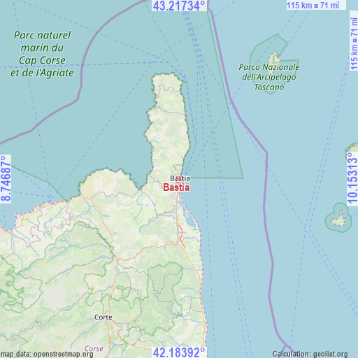
Bastia GPS coordinates[2]
42° 42' 10.008" North, 9° 27' 0" East
| Map corner | latitude | longitude |
|---|---|---|
| Upper-left | 43.21734°, | 8.74687° |
| Center: | 42.70278°, | 9.45° |
| Lower-right: | 42.18392°, | 10.15313° |
| Map W x H: | 114.9×114.9 km | = 71.4×71.4mi |
| max Lat: | 51.07786° ⇑99% North |
| Bastia: | 42.70278° |
| min Lat: | ⇓1% South 41.3874° |
| min Long | Bastia | max Long |
| -5.08615° | 9.45° | 9.52242° |
| W 99.9%⇐ | ⇒0.099999999999994% E |
Elevation
Elevation of Bastia is 16 m = 52 ft, and this is 177.7 m = 583 ft below average elevation for this country.
| Max E: |
2333 m = 7654 ft | 95.4% |
| Avg. | 193.7 m = 635 ft | |
| Bastia | 16 m = 52 ft | |
Min E: |
-1 m = -3 ft | 4.6% |
See also: Bastia elevation on elevation.city.
Geographical zone
Bastia is located in North temperate zone (between Tropic of Cancer and the Arctic Circle). Distance of this Northern Tropic circle is 2142.2 km =1331.1 mi to South.| Distance of | km | miles | from Bastia |
|---|---|---|---|
| North Pole | 5259 | 3267.8 | to North |
| Arctic Circle | 2653.1 | 1648.6 | to North |
| Tropic Cancer | 2142.2 | 1331.1 | to South |
| Equator | 4748.1 | 2950.3 | to South |


Nearby cities:
15 places around Bastia: (largest is in red/bold)
• Biguglia
8.8 km =5.5 mi,  196°
196°
• Borgo
16.6 km =10.3 mi,  186°
186°
• Brando
7.1 km =4.4 mi,  0°
0°
• Furiani
5.7 km =3.5 mi,  210°
210°
• Lucciana
17.6 km =10.9 mi, 188°
• Marine de Pietracorbara
15 km =9.3 mi,  9°
9°
• Marine de Sisco
12.4 km =7.7 mi,  15°
15°
• Murato
17.1 km =10.6 mi,  215°
215°
• Oletta
11.3 km =7 mi, 223°
• Patrimonio
7.2 km =4.5 mi,  265°
265°
• Pietranera
2.3 km =1.4 mi, 12°
• Saint-Florent
12.2 km =7.6 mi,  258°
258°
• San-Martino-di-Lota
3.3 km =2.1 mi,  345°
345°
• Santa-Maria-di-Lota
5.2 km =3.2 mi,  343°
343°
• Sisco
10.9 km =6.8 mi, 352°
Sources, notices
• [Note1] Compared only with cities in France existing in our database
• [Src1] Map data: © OpenStreetMap contributors (CC-BY-SA)
• [Src2] Other city data from geonames.org with taken over terms of usage.
• [Src3] Geographical zone / Annual Mean Temperature by Robert A. Rohde @ Wikipedia
