Beyssac geodata
Beyssac (Nouvelle-Aquitaine) is a populated place; located in France in Europe/Paris (GMT+2) time zone. With population of 794 people, there are 10681 cities with bigger population in this country. Compared to other cities in France, 75.6% of cities are located further ↑North; 64.2% of cities are located further →East and 87.9% of cities have lower elevation than Beyssac. Note1
Administrative division(s):
- Level 1: Nouvelle-Aquitaine
- Level 2: Département de la Corrèze
- Level 3: Arrondissement de Brive-la-Gaillarde
- Level 4: Beyssac


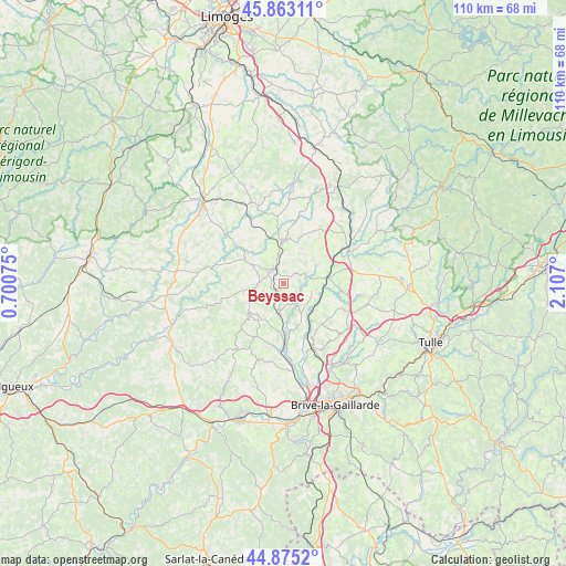
Beyssac GPS coordinates[2]
45° 22' 16.716" North, 1° 24' 13.932" East
| Map corner | latitude | longitude |
|---|---|---|
| Upper-left | 45.86311°, | 0.70075° |
| Center: | 45.37131°, | 1.40387° |
| Lower-right: | 44.8752°, | 2.107° |
| Map W x H: | 109.8×109.8 km | = 68.2×68.2mi |
| max Lat: | 51.07786° ⇑75.6% North |
| Beyssac: | 45.37131° |
| min Lat: | ⇓24.4% South 41.3874° |
| min Long | Beyssac | max Long |
| -5.08615° | 1.40387° | 9.52242° |
| W 35.8%⇐ | ⇒64.2% E |
Elevation
Elevation of Beyssac is 387 m = 1270 ft, and this is 193.3 m = 634 ft above average elevation for this country.
| Max E: |
2333 m = 7654 ft | 12.1% |
| Beyssac | 387 m 1270 ft | |
| Avg. | 193.7 m = 635 ft | |
Min E: |
-1 m = -3 ft | 87.9% |
See also: France elevation on elevation.city.
Geographical zone
Beyssac is located in North temperate zone (between Tropic of Cancer and the Arctic Circle). Distance of this North polar circle is 2356.4 km =1464.2 mi to North.| Distance of | km | miles | from Beyssac |
|---|---|---|---|
| North Pole | 4962.2 | 3083.4 | to North |
| Arctic Circle | 2356.4 | 1464.2 | to North |
| Tropic Cancer | 2438.9 | 1515.5 | to South |
| Equator | 5044.8 | 3134.7 | to South |


Nearby cities:
15 places around Beyssac: (largest is in red/bold)
• Allassac
13.7 km =8.5 mi,  155°
155°
• Arnac-Pompadour
5 km =3.1 mi,  328°
328°
• Juillac
8.7 km =5.4 mi,  227°
227°
• Lubersac
8.2 km =5.1 mi,  0°
0°
• Objat
12 km =7.5 mi,  178°
178°
• Perpezac-le-Noir
12.6 km =7.8 mi,  113°
113°
• Sadroc
15 km =9.3 mi,  130°
130°
• Saint-Sornin-Lavolps
1.8 km =1.1 mi,  294°
294°
• Saint-Ybard
12.5 km =7.8 mi,  47°
47°
• Savignac-Lédrier
14.4 km =8.9 mi,  266°
266°
• Troche
3.4 km =2.1 mi,  57°
57°
• Uzerche
13.8 km =8.6 mi, 64°
• Vigeois
8.9 km =5.5 mi,  84°
84°
• Vignols
5.8 km =3.6 mi,  191°
191°
• Voutezac
9.2 km =5.7 mi, 163°
Sources, notices
• [Note1] Compared only with cities in France existing in our database
• [Src1] Map data: © OpenStreetMap contributors (CC-BY-SA)
• [Src2] Other city data from geonames.org with taken over terms of usage.
• [Src3] Geographical zone / Annual Mean Temperature by Robert A. Rohde @ Wikipedia
