Saint-Ybard geodata
Saint-Ybard (Nouvelle-Aquitaine) is a populated place; located in France in Europe/Paris (GMT+2) time zone. With population of 602 people, there are 13285 cities with bigger population in this country. Compared to other cities in France, 74.7% of cities are located further ↑North; 62.8% of cities are located further →East and 89.1% of cities have lower elevation than Saint-Ybard. Note1
Administrative division(s):
- Level 1: Nouvelle-Aquitaine
- Level 2: Département de la Corrèze
- Level 3: Arrondissement de Tulle
- Level 4: Saint-Ybard


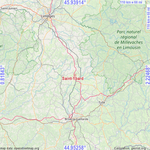
Saint-Ybard GPS coordinates[2]
45° 26' 52.872" North, 1° 31' 17.616" East
| Map corner | latitude | longitude |
|---|---|---|
| Upper-left | 45.93914°, | 0.81843° |
| Center: | 45.44802°, | 1.52156° |
| Lower-right: | 44.95258°, | 2.22468° |
| Map W x H: | 109.7×109.7 km | = 68.2×68.2mi |
| max Lat: | 51.07786° ⇑74.7% North |
| Saint-Ybard: | 45.44802° |
| min Lat: | ⇓25.3% South 41.3874° |
| min Long | Saint-Ybard | max Long |
| -5.08615° | 1.52156° | 9.52242° |
| W 37.2%⇐ | ⇒62.8% E |
Elevation
Elevation of Saint-Ybard is 408 m = 1339 ft, and this is 214.3 m = 703 ft above average elevation for this country.
| Max E: |
2333 m = 7654 ft | 10.9% |
| Saint-Ybard | 408 m 1339 ft | |
| Avg. | 193.7 m = 635 ft | |
Min E: |
-1 m = -3 ft | 89.1% |
See also: France elevation on elevation.city.
Geographical zone
Saint-Ybard is located in North temperate zone (between Tropic of Cancer and the Arctic Circle). Distance of this North polar circle is 2347.8 km =1458.9 mi to North.| Distance of | km | miles | from Saint-Ybard |
|---|---|---|---|
| North Pole | 4953.7 | 3078.1 | to North |
| Arctic Circle | 2347.8 | 1458.9 | to North |
| Tropic Cancer | 2447.4 | 1520.7 | to South |
| Equator | 5053.3 | 3140 | to South |


Nearby cities:
15 places around Saint-Ybard: (largest is in red/bold)
• Arnac-Pompadour
12.6 km =7.8 mi,  250°
250°
• Beyssac
12.5 km =7.8 mi,  227°
227°
• Condat-sur-Ganaveix
6 km =3.7 mi,  69°
69°
• Eyburie
9 km =5.6 mi,  81°
81°
• Lagraulière
14 km =8.7 mi,  139°
139°
• Lubersac
9.1 km =5.7 mi,  267°
267°
• Masseret
10.8 km =6.7 mi,  359°
359°
• Meuzac
13.3 km =8.3 mi,  331°
331°
• Perpezac-le-Noir
13.7 km =8.5 mi,  169°
169°
• Saint-Jal
11.1 km =6.9 mi,  121°
121°
• Saint-Sornin-Lavolps
13.3 km =8.3 mi, 234°
• Salon-la-Tour
6.5 km =4 mi,  11°
11°
• Troche
9.2 km =5.7 mi,  223°
223°
• Uzerche
4.2 km =2.6 mi,  128°
128°
• Vigeois
7.6 km =4.7 mi,  182°
182°
Sources, notices
• [Note1] Compared only with cities in France existing in our database
• [Src1] Map data: © OpenStreetMap contributors (CC-BY-SA)
• [Src2] Other city data from geonames.org with taken over terms of usage.
• [Src3] Geographical zone / Annual Mean Temperature by Robert A. Rohde @ Wikipedia
