Uzerche geodata
Uzerche (Nouvelle-Aquitaine) is a populated place; located in France in Europe/Paris (GMT+2) time zone. With population of 3,143 people, there are 3095 cities with bigger population in this country. Compared to other cities in France, 75% of cities are located further ↑North; 62.2% of cities are located further →East and 84% of cities have lower elevation than Uzerche. Note1
Administrative division(s):
- Level 1: Nouvelle-Aquitaine
- Level 2: Département de la Corrèze
- Level 3: Arrondissement de Tulle
- Level 4: Uzerche


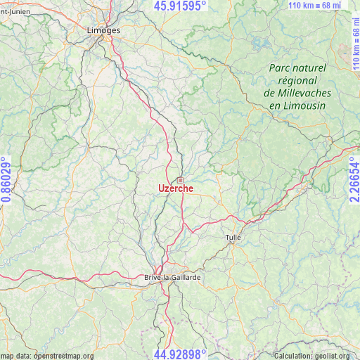
Uzerche GPS coordinates[2]
45° 25' 28.632" North, 1° 33' 48.276" East
| Map corner | latitude | longitude |
|---|---|---|
| Upper-left | 45.91595°, | 0.86029° |
| Center: | 45.42462°, | 1.56341° |
| Lower-right: | 44.92898°, | 2.26654° |
| Map W x H: | 109.7×109.7 km | = 68.2×68.2mi |
| max Lat: | 51.07786° ⇑75% North |
| Uzerche: | 45.42462° |
| min Lat: | ⇓25% South 41.3874° |
| min Long | Uzerche | max Long |
| -5.08615° | 1.56341° | 9.52242° |
| W 37.8%⇐ | ⇒62.2% E |
Elevation
Elevation of Uzerche is 334 m = 1096 ft, and this is 140.3 m = 460 ft above average elevation for this country.
| Max E: |
2333 m = 7654 ft | 16% |
| Uzerche | 334 m 1096 ft | |
| Avg. | 193.7 m = 635 ft | |
Min E: |
-1 m = -3 ft | 84% |
See also: France elevation on elevation.city.
Geographical zone
Uzerche is located in North temperate zone (between Tropic of Cancer and the Arctic Circle). Distance of this North polar circle is 2350.4 km =1460.5 mi to North.| Distance of | km | miles | from Uzerche |
|---|---|---|---|
| North Pole | 4956.3 | 3079.7 | to North |
| Arctic Circle | 2350.4 | 1460.5 | to North |
| Tropic Cancer | 2444.8 | 1519.1 | to South |
| Equator | 5050.7 | 3138.4 | to South |


Nearby cities:
15 places around Uzerche: (largest is in red/bold)
• Beyssac
13.8 km =8.6 mi,  244°
244°
• Chamboulive
11 km =6.8 mi,  85°
85°
• Condat-sur-Ganaveix
5.3 km =3.3 mi,  26°
26°
• Eyburie
6.9 km =4.3 mi,  55°
55°
• Lagraulière
9.9 km =6.2 mi,  143°
143°
• Le Lonzac
13.6 km =8.5 mi,  71°
71°
• Lubersac
12.6 km =7.8 mi,  280°
280°
• Perpezac-le-Noir
11 km =6.8 mi,  184°
184°
• Saint-Clément
13.3 km =8.3 mi,  134°
134°
• Saint-Jal
7 km =4.3 mi,  116°
116°
• Saint-Ybard
4.2 km =2.6 mi,  308°
308°
• Salon-la-Tour
9.1 km =5.7 mi,  347°
347°
• Seilhac
13.4 km =8.3 mi, 118°
• Troche
10.4 km =6.5 mi,  246°
246°
• Vigeois
6.2 km =3.9 mi,  215°
215°
Sources, notices
• [Note1] Compared only with cities in France existing in our database
• [Src1] Map data: © OpenStreetMap contributors (CC-BY-SA)
• [Src2] Other city data from geonames.org with taken over terms of usage.
• [Src3] Geographical zone / Annual Mean Temperature by Robert A. Rohde @ Wikipedia
