Berry-au-Bac geodata
Berry-au-Bac (Hauts-de-France) is a populated place; located in France in Europe/Paris (GMT+2) time zone. With population of 526 people, there are 14691 cities with bigger population in this country. Compared to other cities in France, 87.9% of cities are located further ↓South; 66.9% of cities are located further ←West and 80.2% of cities have higher elevation than Berry-au-Bac. Note1
Administrative division(s):
- Level 1: Hauts-de-France
- Level 2: Département de l'Aisne
- Level 3: Arrondissement de Laon
- Level 4: Berry-au-Bac


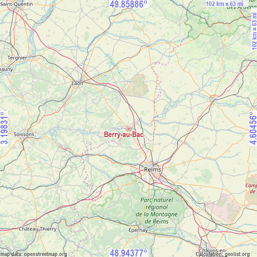
Berry-au-Bac GPS coordinates[2]
49° 24' 12.42" North, 3° 54' 5.148" East
| Map corner | latitude | longitude |
|---|---|---|
| Upper-left | 49.85886°, | 3.19831° |
| Center: | 49.40345°, | 3.90143° |
| Lower-right: | 48.94377°, | 4.60456° |
| Map W x H: | 101.7×101.7 km | = 63.2×63.2mi |
| max Lat: | 51.07786° ⇑12.1% North |
| Berry-au-Bac: | 49.40345° |
| min Lat: | ⇓87.9% South 41.3874° |
| min Long | Berry-au-Bac | max Long |
| -5.08615° | 3.90143° | 9.52242° |
| W 66.9%⇐ | ⇒33.1% E |
Elevation
Elevation of Berry-au-Bac is 54 m = 177 ft, and this is 139.7 m = 458 ft below average elevation for this country.
| Max E: |
2333 m = 7654 ft | 80.2% |
| Avg. | 193.7 m = 635 ft | |
| Berry-au-Bac | 54 m = 177 ft | |
Min E: |
-1 m = -3 ft | 19.8% |
See also: France elevation on elevation.city.
Geographical zone
Berry-au-Bac is located in North temperate zone (between Tropic of Cancer and the Arctic Circle). Distance of this North polar circle is 1908 km =1185.6 mi to North.| Distance of | km | miles | from Berry-au-Bac |
|---|---|---|---|
| North Pole | 4513.9 | 2804.8 | to North |
| Arctic Circle | 1908 | 1185.6 | to North |
| Tropic Cancer | 2887.2 | 1794 | to South |
| Equator | 5493.1 | 3413.3 | to South |


Nearby cities:
15 places around Berry-au-Bac: (largest is in red/bold)
• Auménancourt-le-Petit
11.8 km =7.3 mi,  104°
104°
• Beaurieux
11.7 km =7.3 mi,  264°
264°
• Corbeny
8.7 km =5.4 mi,  319°
319°
• Cormicy
3.7 km =2.3 mi,  186°
186°
• Courcy
11.5 km =7.1 mi,  140°
140°
• Guignicourt
6.1 km =3.8 mi,  51°
51°
• Hermonville
7.5 km =4.7 mi,  175°
175°
• Loivre
8.5 km =5.3 mi, 138°
• Merfy
12.4 km =7.7 mi,  163°
163°
• Neufchâtel-sur-Aisne
10.1 km =6.3 mi,  72°
72°
• Prouilly
12 km =7.5 mi,  196°
196°
• Saint-Erme-Outre-et-Ramecourt
13.1 km =8.1 mi,  340°
340°
• Saint-Thierry
11.8 km =7.3 mi, 156°
• Trigny
11.2 km =7 mi, 182°
• Évergnicourt
11 km =6.8 mi, 66°
Sources, notices
• [Note1] Compared only with cities in France existing in our database
• [Src1] Map data: © OpenStreetMap contributors (CC-BY-SA)
• [Src2] Other city data from geonames.org with taken over terms of usage.
• [Src3] Geographical zone / Annual Mean Temperature by Robert A. Rohde @ Wikipedia
