Corbeny geodata
Corbeny (Hauts-de-France) is a populated place; located in France in Europe/Paris (GMT+2) time zone. With population of 640 people, there are 12673 cities with bigger population in this country. Compared to other cities in France, 88.7% of cities are located further ↓South; 66.5% of cities are located further ←West and 64.4% of cities have higher elevation than Corbeny. Note1
Administrative division(s):
- Level 1: Hauts-de-France
- Level 2: Département de l'Aisne
- Level 3: Arrondissement de Laon
- Level 4: Corbeny


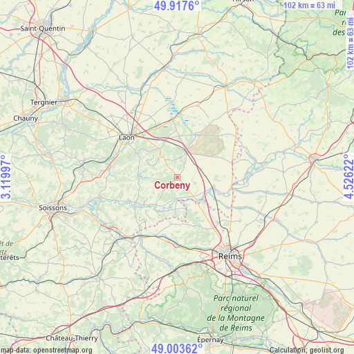
Corbeny GPS coordinates[2]
49° 27' 45.864" North, 3° 49' 23.124" East
| Map corner | latitude | longitude |
|---|---|---|
| Upper-left | 49.9176°, | 3.11997° |
| Center: | 49.46274°, | 3.82309° |
| Lower-right: | 49.00362°, | 4.52622° |
| Map W x H: | 101.6×101.6 km | = 63.1×63.1mi |
| max Lat: | 51.07786° ⇑11.3% North |
| Corbeny: | 49.46274° |
| min Lat: | ⇓88.7% South 41.3874° |
| min Long | Corbeny | max Long |
| -5.08615° | 3.82309° | 9.52242° |
| W 66.5%⇐ | ⇒33.5% E |
Elevation
Elevation of Corbeny is 91 m = 299 ft, and this is 102.7 m = 337 ft below average elevation for this country.
| Max E: |
2333 m = 7654 ft | 64.4% |
| Avg. | 193.7 m = 635 ft | |
| Corbeny | 91 m = 299 ft | |
Min E: |
-1 m = -3 ft | 35.6% |
See also: France elevation on elevation.city.
Geographical zone
Corbeny is located in North temperate zone (between Tropic of Cancer and the Arctic Circle). Distance of this North polar circle is 1901.4 km =1181.5 mi to North.| Distance of | km | miles | from Corbeny |
|---|---|---|---|
| North Pole | 4507.3 | 2800.7 | to North |
| Arctic Circle | 1901.4 | 1181.5 | to North |
| Tropic Cancer | 2893.8 | 1798.1 | to South |
| Equator | 5499.7 | 3417.4 | to South |


Nearby cities:
15 places around Corbeny: (largest is in red/bold)
• Beaurieux
9.8 km =6.1 mi,  217°
217°
• Berry-au-Bac
8.7 km =5.4 mi,  139°
139°
• Bourg-et-Comin
14.2 km =8.8 mi,  239°
239°
• Bruyères-et-Montbérault
13.5 km =8.4 mi,  301°
301°
• Cormicy
11.5 km =7.1 mi,  152°
152°
• Coucy-lès-Eppes
10.7 km =6.6 mi,  340°
340°
• Festieux
8.3 km =5.2 mi,  323°
323°
• Gizy
15.8 km =9.8 mi,  347°
347°
• Guignicourt
10.8 km =6.7 mi,  105°
105°
• Hermonville
15.4 km =9.6 mi,  155°
155°
• Montaigu
8.1 km =5 mi,  4°
4°
• Neufchâtel-sur-Aisne
15.6 km =9.7 mi,  102°
102°
• Saint-Erme-Outre-et-Ramecourt
5.9 km =3.7 mi,  12°
12°
• Sissonne
13.1 km =8.1 mi,  22°
22°
• Évergnicourt
15.9 km =9.9 mi, 97°
Sources, notices
• [Note1] Compared only with cities in France existing in our database
• [Src1] Map data: © OpenStreetMap contributors (CC-BY-SA)
• [Src2] Other city data from geonames.org with taken over terms of usage.
• [Src3] Geographical zone / Annual Mean Temperature by Robert A. Rohde @ Wikipedia
