Loivre geodata
Loivre (Grand Est) is a populated place; located in France in Europe/Paris (GMT+2) time zone. With population of 1,105 people, there are 8096 cities with bigger population in this country. Compared to other cities in France, 86.9% of cities are located further ↓South; 67.6% of cities are located further ←West and 73.6% of cities have higher elevation than Loivre. Note1
Administrative division(s):
- Level 1: Grand Est
- Level 2: Marne
- Level 3: Arrondissement de Reims
- Level 4: Loivre


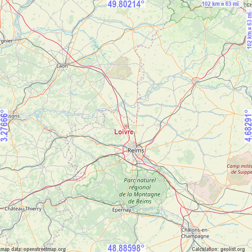
Loivre GPS coordinates[2]
49° 20' 46.284" North, 3° 58' 47.208" East
| Map corner | latitude | longitude |
|---|---|---|
| Upper-left | 49.80214°, | 3.27666° |
| Center: | 49.34619°, | 3.97978° |
| Lower-right: | 48.88598°, | 4.68291° |
| Map W x H: | 101.9×101.9 km | = 63.3×63.3mi |
| max Lat: | 51.07786° ⇑13.1% North |
| Loivre: | 49.34619° |
| min Lat: | ⇓86.9% South 41.3874° |
| min Long | Loivre | max Long |
| -5.08615° | 3.97978° | 9.52242° |
| W 67.6%⇐ | ⇒32.4% E |
Elevation
Elevation of Loivre is 70 m = 230 ft, and this is 123.7 m = 406 ft below average elevation for this country.
| Max E: |
2333 m = 7654 ft | 73.6% |
| Avg. | 193.7 m = 635 ft | |
| Loivre | 70 m = 230 ft | |
Min E: |
-1 m = -3 ft | 26.4% |
See also: France elevation on elevation.city.
Geographical zone
Loivre is located in North temperate zone (between Tropic of Cancer and the Arctic Circle). Distance of this North polar circle is 1914.4 km =1189.6 mi to North.| Distance of | km | miles | from Loivre |
|---|---|---|---|
| North Pole | 4520.3 | 2808.8 | to North |
| Arctic Circle | 1914.4 | 1189.6 | to North |
| Tropic Cancer | 2880.9 | 1790.1 | to South |
| Equator | 5486.8 | 3409.3 | to South |


Nearby cities:
15 places around Loivre: (largest is in red/bold)
• Auménancourt-le-Petit
6.7 km =4.2 mi,  59°
59°
• Berry-au-Bac
8.5 km =5.3 mi,  318°
318°
• Bourgogne
6.6 km =4.1 mi,  86°
86°
• Bétheny
8.7 km =5.4 mi,  141°
141°
• Champigny
8.7 km =5.4 mi,  184°
184°
• Cormicy
6.7 km =4.2 mi,  294°
294°
• Courcy
3 km =1.9 mi,  146°
146°
• Hermonville
5.2 km =3.2 mi,  258°
258°
• Merfy
6 km =3.7 mi,  201°
201°
• Muizon
10.2 km =6.3 mi,  219°
219°
• Neufchâtel-sur-Aisne
10.2 km =6.3 mi,  22°
22°
• Reims
9.7 km =6 mi,  158°
158°
• Saint-Brice-Courcelles
8.8 km =5.5 mi, 178°
• Saint-Thierry
4.6 km =2.9 mi,  192°
192°
• Trigny
7.8 km =4.8 mi,  231°
231°
Sources, notices
• [Note1] Compared only with cities in France existing in our database
• [Src1] Map data: © OpenStreetMap contributors (CC-BY-SA)
• [Src2] Other city data from geonames.org with taken over terms of usage.
• [Src3] Geographical zone / Annual Mean Temperature by Robert A. Rohde @ Wikipedia
