Benet geodata
Benet (Pays de la Loire) is a populated place; located in France in Europe/Paris (GMT+2) time zone. With population of 3,471 people, there are 2803 cities with bigger population in this country. Compared to other cities in France, 61.5% of cities are located further ↑North; 84.4% of cities are located further →East and 91.6% of cities have higher elevation than Benet. Note1
Administrative division(s):
- Level 1: Pays de la Loire
- Level 2: Département de la Vendée
- Level 3: Arrondissement de Fontenay-le-Comte
- Level 4: Benet


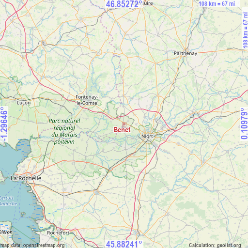
Benet GPS coordinates[2]
46° 22' 10.992" North, 0° 35' 35.988" West
| Map corner | latitude | longitude |
|---|---|---|
| Upper-left | 46.85272°, | -1.29646° |
| Center: | 46.36972°, | -0.59333° |
| Lower-right: | 45.88241°, | 0.10979° |
| Map W x H: | 107.9×107.9 km | = 67×67mi |
| max Lat: | 51.07786° ⇑61.5% North |
| Benet: | 46.36972° |
| min Lat: | ⇓38.5% South 41.3874° |
| min Long | Benet | max Long |
| -5.08615° | -0.59333° | 9.52242° |
| W 15.6%⇐ | ⇒84.4% E |
Elevation
Elevation of Benet is 26 m = 85 ft, and this is 167.7 m = 550 ft below average elevation for this country.
| Max E: |
2333 m = 7654 ft | 91.6% |
| Avg. | 193.7 m = 635 ft | |
| Benet | 26 m = 85 ft | |
Min E: |
-1 m = -3 ft | 8.4% |
See also: France elevation on elevation.city.
Geographical zone
Benet is located in North temperate zone (between Tropic of Cancer and the Arctic Circle). Distance of this North polar circle is 2245.3 km =1395.2 mi to North.| Distance of | km | miles | from Benet |
|---|---|---|---|
| North Pole | 4851.2 | 3014.4 | to North |
| Arctic Circle | 2245.3 | 1395.2 | to North |
| Tropic Cancer | 2549.9 | 1584.4 | to South |
| Equator | 5155.8 | 3203.7 | to South |


Nearby cities:
15 places around Benet: (largest is in red/bold)
• Ardin
11.9 km =7.4 mi,  13°
13°
• Arçais
11.1 km =6.9 mi,  222°
222°
• Bessines
9.6 km =6 mi,  141°
141°
• Coulon
5.1 km =3.2 mi,  172°
172°
• Magné
7 km =4.3 mi,  149°
149°
• Maillezais
11.2 km =7 mi,  271°
271°
• Niort
11.6 km =7.2 mi,  116°
116°
• Oulmes
6.6 km =4.1 mi,  300°
300°
• Saint-Maxire
9.4 km =5.8 mi,  69°
69°
• Saint-Pierre-le-Vieux
12.1 km =7.5 mi,  278°
278°
• Saint-Pompain
8 km =5 mi,  356°
356°
• Saint-Rémy
5.1 km =3.2 mi,  88°
88°
• Sansais
10.6 km =6.6 mi,  177°
177°
• Sciecq
9.4 km =5.8 mi, 87°
• Villiers-en-Plaine
6.1 km =3.8 mi,  44°
44°
Sources, notices
• [Note1] Compared only with cities in France existing in our database
• [Src1] Map data: © OpenStreetMap contributors (CC-BY-SA)
• [Src2] Other city data from geonames.org with taken over terms of usage.
• [Src3] Geographical zone / Annual Mean Temperature by Robert A. Rohde @ Wikipedia
