Ardin geodata
Ardin (Nouvelle-Aquitaine) is a populated place; located in France in Europe/Paris (GMT+2) time zone. With population of 1,185 people, there are 7621 cities with bigger population in this country. Compared to other cities in France, 60.3% of cities are located further ↑North; 84% of cities are located further →East and 76.2% of cities have higher elevation than Ardin. Note1
Administrative division(s):
- Level 1: Nouvelle-Aquitaine
- Level 2: Département des Deux-Sèvres
- Level 3: Arrondissement de Parthenay
- Level 4: Ardin


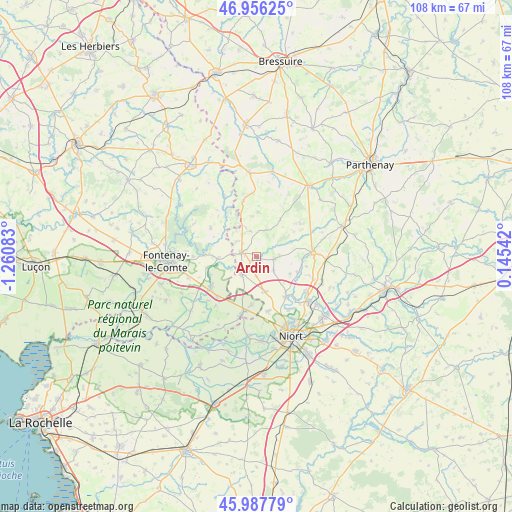
Ardin GPS coordinates[2]
46° 28' 27.012" North, 0° 33' 27.72" West
| Map corner | latitude | longitude |
|---|---|---|
| Upper-left | 46.95625°, | -1.26083° |
| Center: | 46.47417°, | -0.5577° |
| Lower-right: | 45.98779°, | 0.14542° |
| Map W x H: | 107.7×107.7 km | = 66.9×66.9mi |
| max Lat: | 51.07786° ⇑60.3% North |
| Ardin: | 46.47417° |
| min Lat: | ⇓39.7% South 41.3874° |
| min Long | Ardin | max Long |
| -5.08615° | -0.5577° | 9.52242° |
| W 16%⇐ | ⇒84% E |
Elevation
Elevation of Ardin is 64 m = 210 ft, and this is 129.7 m = 426 ft below average elevation for this country.
| Max E: |
2333 m = 7654 ft | 76.2% |
| Avg. | 193.7 m = 635 ft | |
| Ardin | 64 m = 210 ft | |
Min E: |
-1 m = -3 ft | 23.8% |
See also: France elevation on elevation.city.
Geographical zone
Ardin is located in North temperate zone (between Tropic of Cancer and the Arctic Circle). Distance of this North polar circle is 2233.7 km =1388 mi to North.| Distance of | km | miles | from Ardin |
|---|---|---|---|
| North Pole | 4839.6 | 3007.2 | to North |
| Arctic Circle | 2233.7 | 1388 | to North |
| Tropic Cancer | 2561.5 | 1591.6 | to South |
| Equator | 5167.4 | 3210.9 | to South |


Nearby cities:
15 places around Ardin: (largest is in red/bold)
• Benet
11.9 km =7.4 mi,  193°
193°
• Béceleuf
3.9 km =2.4 mi,  94°
94°
• Champdeniers-Saint-Denis
12.1 km =7.5 mi, 85°
• Coulonges-sur-l’Autize
3.3 km =2.1 mi,  288°
288°
• Foussais-Payré
11.6 km =7.2 mi,  304°
304°
• Germond-Rouvre
11.1 km =6.9 mi,  103°
103°
• Oulmes
11.7 km =7.3 mi,  225°
225°
• Saint-Hilaire-des-Loges
8.1 km =5 mi,  268°
268°
• Saint-Maxire
10.3 km =6.4 mi,  143°
143°
• Saint-Pompain
4.9 km =3 mi,  221°
221°
• Saint-Rémy
11.7 km =7.3 mi,  168°
168°
• Sainte-Ouenne
9.3 km =5.8 mi,  111°
111°
• Surin
7.4 km =4.6 mi, 101°
• Villiers-en-Plaine
7.4 km =4.6 mi, 167°
• Xanton-Chassenon
10.8 km =6.7 mi,  257°
257°
Sources, notices
• [Note1] Compared only with cities in France existing in our database
• [Src1] Map data: © OpenStreetMap contributors (CC-BY-SA)
• [Src2] Other city data from geonames.org with taken over terms of usage.
• [Src3] Geographical zone / Annual Mean Temperature by Robert A. Rohde @ Wikipedia
