Villiers-en-Plaine geodata
Villiers-en-Plaine (Nouvelle-Aquitaine) is a populated place; located in France in Europe/Paris (GMT+2) time zone. With population of 1,343 people, there are 6854 cities with bigger population in this country. Compared to other cities in France, 61% of cities are located further ↑North; 83.8% of cities are located further →East and 84.9% of cities have higher elevation than Villiers-en-Plaine. Note1
Administrative division(s):
- Level 1: Nouvelle-Aquitaine
- Level 2: Département des Deux-Sèvres
- Level 3: Arrondissement de Niort
- Level 4: Villiers-en-Plaine


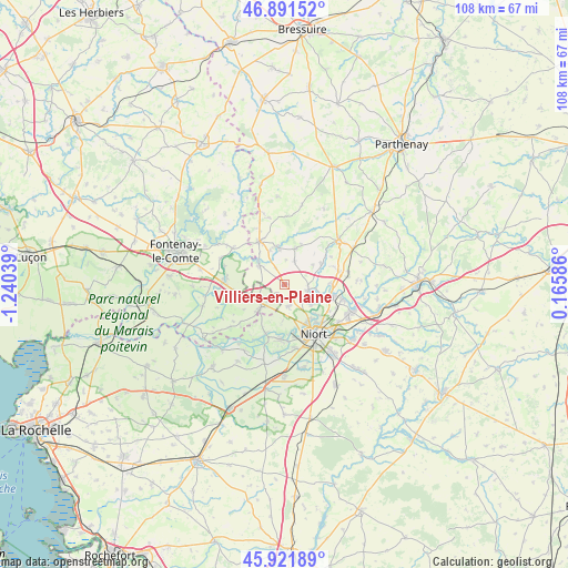
Villiers-en-Plaine GPS coordinates[2]
46° 24' 31.896" North, 0° 32' 14.136" West
| Map corner | latitude | longitude |
|---|---|---|
| Upper-left | 46.89152°, | -1.24039° |
| Center: | 46.40886°, | -0.53726° |
| Lower-right: | 45.92189°, | 0.16586° |
| Map W x H: | 107.8×107.8 km | = 67×67mi |
| max Lat: | 51.07786° ⇑61% North |
| Villiers-en-Plaine: | 46.40886° |
| min Lat: | ⇓39% South 41.3874° |
| min Long | Villiers-en-Pla | max Long |
| -5.08615° | -0.53726° | 9.52242° |
| W 16.2%⇐ | ⇒83.8% E |
Elevation
Elevation of Villiers-en-Plaine is 42 m = 138 ft, and this is 151.7 m = 498 ft below average elevation for this country.
| Max E: |
2333 m = 7654 ft | 84.9% |
| Avg. | 193.7 m = 635 ft | |
| Villiers-en-Plaine | 42 m = 138 ft | |
Min E: |
-1 m = -3 ft | 15.1% |
See also: France elevation on elevation.city.
Geographical zone
Villiers-en-Plaine is located in North temperate zone (between Tropic of Cancer and the Arctic Circle). Distance of this North polar circle is 2241 km =1392.5 mi to North.| Distance of | km | miles | from Villiers-en-Plaine |
|---|---|---|---|
| North Pole | 4846.9 | 3011.7 | to North |
| Arctic Circle | 2241 | 1392.5 | to North |
| Tropic Cancer | 2554.3 | 1587.2 | to South |
| Equator | 5160.2 | 3206.4 | to South |


Nearby cities:
15 places around Villiers-en-Plaine: (largest is in red/bold)
• Ardin
7.4 km =4.6 mi,  347°
347°
• Benet
6.1 km =3.8 mi,  224°
224°
• Béceleuf
7.3 km =4.5 mi,  18°
18°
• Coulon
10.1 km =6.3 mi,  201°
201°
• Coulonges-sur-l’Autize
9.5 km =5.9 mi,  330°
330°
• Germond-Rouvre
10.3 km =6.4 mi,  63°
63°
• Magné
10.4 km =6.5 mi,  184°
184°
• Oulmes
10 km =6.2 mi,  264°
264°
• Saint-Maxire
4.6 km =2.9 mi,  102°
102°
• Saint-Pompain
6 km =3.7 mi,  306°
306°
• Saint-Rémy
4.3 km =2.7 mi,  169°
169°
• Sainte-Ouenne
8.1 km =5 mi, 60°
• Sciecq
6.5 km =4 mi,  128°
128°
• Surin
8.1 km =5 mi,  44°
44°
• Échiré
9.6 km =6 mi, 102°
Sources, notices
• [Note1] Compared only with cities in France existing in our database
• [Src1] Map data: © OpenStreetMap contributors (CC-BY-SA)
• [Src2] Other city data from geonames.org with taken over terms of usage.
• [Src3] Geographical zone / Annual Mean Temperature by Robert A. Rohde @ Wikipedia
