Sury-en-Vaux geodata
Sury-en-Vaux (Centre) is a populated place; located in France in Europe/Paris (GMT+2) time zone. With population of 732 people, there are 11386 cities with bigger population in this country. Compared to other cities in France, 50.5% of cities are located further ↑North; 55% of cities are located further ←West and 72.2% of cities have lower elevation than Sury-en-Vaux. Note1
Administrative division(s):
- Level 1: Centre
- Level 2: Cher
- Level 3: Arrondissement de Bourges
- Level 4: Sury-en-Vaux


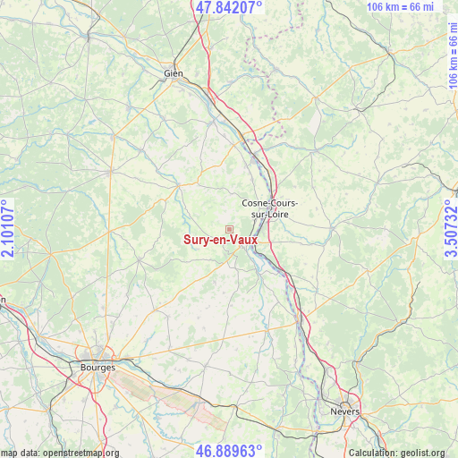
Sury-en-Vaux GPS coordinates[2]
47° 22' 4.8" North, 2° 48' 15.084" East
| Map corner | latitude | longitude |
|---|---|---|
| Upper-left | 47.84207°, | 2.10107° |
| Center: | 47.368°, | 2.80419° |
| Lower-right: | 46.88963°, | 3.50732° |
| Map W x H: | 105.9×105.9 km | = 65.8×65.8mi |
| max Lat: | 51.07786° ⇑50.5% North |
| Sury-en-Vaux: | 47.368° |
| min Lat: | ⇓49.5% South 41.3874° |
| min Long | Sury-en-Vaux | max Long |
| -5.08615° | 2.80419° | 9.52242° |
| W 55%⇐ | ⇒45% E |
Elevation
Elevation of Sury-en-Vaux is 231 m = 758 ft, and this is 37.3 m = 122 ft above average elevation for this country.
| Max E: |
2333 m = 7654 ft | 27.8% |
| Sury-en-Vaux | 231 m 758 ft | |
| Avg. | 193.7 m = 635 ft | |
Min E: |
-1 m = -3 ft | 72.2% |
See also: France elevation on elevation.city.
Geographical zone
Sury-en-Vaux is located in North temperate zone (between Tropic of Cancer and the Arctic Circle). Distance of this North polar circle is 2134.3 km =1326.2 mi to North.| Distance of | km | miles | from Sury-en-Vaux |
|---|---|---|---|
| North Pole | 4740.2 | 2945.4 | to North |
| Arctic Circle | 2134.3 | 1326.2 | to North |
| Tropic Cancer | 2660.9 | 1653.4 | to South |
| Equator | 5266.8 | 3272.6 | to South |


Nearby cities:
15 places around Sury-en-Vaux: (largest is in red/bold)
• Bannay
6.4 km =4 mi,  69°
69°
• Boulleret
8.1 km =5 mi,  39°
39°
• Cosne-Cours-sur-Loire
10.3 km =6.4 mi,  62°
62°
• Crézancy-en-Sancerre
8.6 km =5.3 mi,  208°
208°
• Jars
9.7 km =6 mi,  288°
288°
• Léré
12.2 km =7.6 mi,  23°
23°
• Myennes
13 km =8.1 mi,  48°
48°
• Pouilly-sur-Loire
14.7 km =9.1 mi,  129°
129°
• Saint-Andelain
13.5 km =8.4 mi,  119°
119°
• Saint-Satur
4.1 km =2.5 mi,  142°
142°
• Sancerre
4.9 km =3 mi,  152°
152°
• Savigny-en-Sancerre
8.2 km =5.1 mi,  2°
2°
• Sury-près-Léré
13.8 km =8.6 mi, 20°
• Tracy-sur-Loire
8.2 km =5.1 mi, 130°
• Veaugues
12.8 km =8 mi,  196°
196°
Sources, notices
• [Note1] Compared only with cities in France existing in our database
• [Src1] Map data: © OpenStreetMap contributors (CC-BY-SA)
• [Src2] Other city data from geonames.org with taken over terms of usage.
• [Src3] Geographical zone / Annual Mean Temperature by Robert A. Rohde @ Wikipedia
