Bégadan geodata
Bégadan (Nouvelle-Aquitaine) is a populated place; located in France in Europe/Paris (GMT+2) time zone. With population of 950 people, there are 9204 cities with bigger population in this country. Compared to other cities in France, 75.7% of cities are located further ↑North; 87.3% of cities are located further →East and 96.7% of cities have higher elevation than Bégadan. Note1
Administrative division(s):
- Level 1: Nouvelle-Aquitaine
- Level 2: Gironde
- Level 3: Arrondissement de Lesparre-Médoc
- Level 4: Bégadan


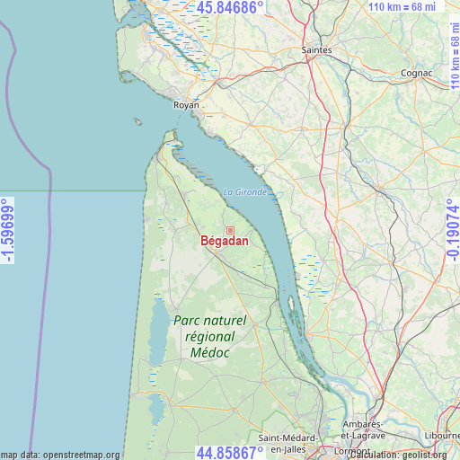
Bégadan GPS coordinates[2]
45° 21' 17.712" North, 0° 53' 37.932" West
| Map corner | latitude | longitude |
|---|---|---|
| Upper-left | 45.84686°, | -1.59699° |
| Center: | 45.35492°, | -0.89387° |
| Lower-right: | 44.85867°, | -0.19074° |
| Map W x H: | 109.9×109.9 km | = 68.3×68.3mi |
| max Lat: | 51.07786° ⇑75.7% North |
| Bégadan: | 45.35492° |
| min Lat: | ⇓24.3% South 41.3874° |
| min Long | Bégadan | max Long |
| -5.08615° | -0.89387° | 9.52242° |
| W 12.7%⇐ | ⇒87.3% E |
Elevation
Elevation of Bégadan is 12 m = 39 ft, and this is 181.7 m = 596 ft below average elevation for this country.
| Max E: |
2333 m = 7654 ft | 96.7% |
| Avg. | 193.7 m = 635 ft | |
| Bégadan | 12 m = 39 ft | |
Min E: |
-1 m = -3 ft | 3.3% |
See also: France elevation on elevation.city.
Geographical zone
Bégadan is located in North temperate zone (between Tropic of Cancer and the Arctic Circle). Distance of this North polar circle is 2358.2 km =1465.3 mi to North.| Distance of | km | miles | from Bégadan |
|---|---|---|---|
| North Pole | 4964.1 | 3084.5 | to North |
| Arctic Circle | 2358.2 | 1465.3 | to North |
| Tropic Cancer | 2437.1 | 1514.3 | to South |
| Equator | 5043 | 3133.6 | to South |


Nearby cities:
15 places around Bégadan: (largest is in red/bold)
• Chenac-Saint-Seurin-d'Uzet
19 km =11.8 mi,  18°
18°
• Gaillan-en-Médoc
6.2 km =3.9 mi,  233°
233°
• Lesparre-Médoc
6.3 km =3.9 mi,  212°
212°
• Mortagne-sur-Gironde
16.3 km =10.1 mi,  30°
30°
• Naujac-sur-Mer
15.2 km =9.4 mi,  222°
222°
• Pauillac
21 km =13 mi,  147°
147°
• Saint-Bonnet-sur-Gironde
18.3 km =11.4 mi,  90°
90°
• Saint-Dizant-du-Gua
17.2 km =10.7 mi,  59°
59°
• Saint-Estèphe
14 km =8.7 mi,  137°
137°
• Saint-Fort-sur-Gironde
17.9 km =11.1 mi,  48°
48°
• Saint-Sauveur
17.6 km =10.9 mi,  164°
164°
• Saint-Seurin-de-Cadourne
11.2 km =7 mi,  132°
132°
• Saint-Vivien-de-Médoc
13.5 km =8.4 mi,  306°
306°
• Vendays-Montalivet
13 km =8.1 mi,  270°
270°
• Vertheuil
12.6 km =7.8 mi, 157°
Sources, notices
• [Note1] Compared only with cities in France existing in our database
• [Src1] Map data: © OpenStreetMap contributors (CC-BY-SA)
• [Src2] Other city data from geonames.org with taken over terms of usage.
• [Src3] Geographical zone / Annual Mean Temperature by Robert A. Rohde @ Wikipedia
