Chenac-Saint-Seurin-d'Uzet geodata
Chenac-Saint-Seurin-d'Uzet (Nouvelle-Aquitaine) is a populated place; located in France in Europe/Paris (GMT+2) time zone. With population of 619 people, there are 13004 cities with bigger population in this country. Compared to other cities in France, 73.9% of cities are located further ↑North; 86.6% of cities are located further →East and 88.3% of cities have higher elevation than Chenac-Saint-Seurin-d'Uzet. Note1
Administrative division(s):
- Level 1: Nouvelle-Aquitaine
- Level 2: Charente-Maritime
- Level 3: Arrondissement de Saintes
- Level 4: Chenac-Saint-Seurin-d'Uzet
Current local time in Chenac-Saint-Seurin-d'Uzet:
03:45 PM, SaturdayDifference from your time zone: hours


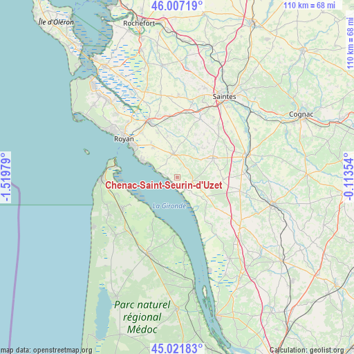
Chenac-Saint-Seurin-d'Uzet GPS coordinates[2]
45° 31' 0.012" North, 0° 49' 0.012" West
| Map corner | latitude | longitude |
|---|---|---|
| Upper-left | 46.00719°, | -1.51979° |
| Center: | 45.51667°, | -0.81667° |
| Lower-right: | 45.02183°, | -0.11354° |
| Map W x H: | 109.6×109.6 km | = 68.1×68.1mi |
| max Lat: | 51.07786° ⇑73.9% North |
| Chenac-Saint-Seurin-d'Uzet: | 45.51667° |
| min Lat: | ⇓26.1% South 41.3874° |
| min Long | Chenac-Saint-Se | max Long |
| -5.08615° | -0.81667° | 9.52242° |
| W 13.4%⇐ | ⇒86.6% E |
Elevation
Elevation of Chenac-Saint-Seurin-d'Uzet is 34 m = 112 ft, and this is 159.7 m = 524 ft below average elevation for this country.
| Max E: |
2333 m = 7654 ft | 88.3% |
| Avg. | 193.7 m = 635 ft | |
| Chenac-Saint-Seurin-d'Uzet | 34 m = 112 ft | |
Min E: |
-1 m = -3 ft | 11.7% |
See also: France elevation on elevation.city.
Geographical zone
Chenac-Saint-Seurin-d'Uzet is located in North temperate zone (between Tropic of Cancer and the Arctic Circle). Distance of this North polar circle is 2340.2 km =1454.1 mi to North.| Distance of | km | miles | from Chenac-Saint-Seurin-d'Uzet |
|---|---|---|---|
| North Pole | 4946.1 | 3073.4 | to North |
| Arctic Circle | 2340.2 | 1454.1 | to North |
| Tropic Cancer | 2455.1 | 1525.5 | to South |
| Equator | 5061 | 3144.8 | to South |


Nearby cities:
15 places around Chenac-Saint-Seurin-d'Uzet: (largest is in red/bold)
• Arces
5.4 km =3.4 mi,  313°
313°
• Champagnolles
14.1 km =8.8 mi,  91°
91°
• Corme-Écluse
13 km =8.1 mi,  346°
346°
• Cozes
7.6 km =4.7 mi, 351°
• Cravans
12.1 km =7.5 mi,  42°
42°
• Grézac
9.8 km =6.1 mi, 348°
• Gémozac
12.4 km =7.7 mi,  62°
62°
• Meschers-sur-Gironde
11.8 km =7.3 mi,  294°
294°
• Montpellier-de-Médillan
14.3 km =8.9 mi,  23°
23°
• Mortagne-sur-Gironde
4.6 km =2.9 mi,  149°
149°
• Saint-André-de-Lidon
10.7 km =6.6 mi,  29°
29°
• Saint-Dizant-du-Gua
12.9 km =8 mi,  136°
136°
• Saint-Fort-sur-Gironde
9.7 km =6 mi,  129°
129°
• Semussac
12.1 km =7.5 mi,  319°
319°
• Épargnes
3 km =1.9 mi, 21°
Sources, notices
• [Note1] Compared only with cities in France existing in our database
• [Src1] Map data: © OpenStreetMap contributors (CC-BY-SA)
• [Src2] Other city data from geonames.org with taken over terms of usage.
• [Src3] Geographical zone / Annual Mean Temperature by Robert A. Rohde @ Wikipedia
