Mortagne-sur-Gironde geodata
Mortagne-sur-Gironde (Nouvelle-Aquitaine) is a populated place; located in France in Europe/Paris (GMT+2) time zone. With population of 1,034 people, there are 8580 cities with bigger population in this country. Compared to other cities in France, 74.3% of cities are located further ↑North; 86.3% of cities are located further →East and 82.2% of cities have higher elevation than Mortagne-sur-Gironde. Note1
Administrative division(s):
- Level 1: Nouvelle-Aquitaine
- Level 2: Charente-Maritime
- Level 3: Arrondissement de Saintes
- Level 4: Mortagne-sur-Gironde


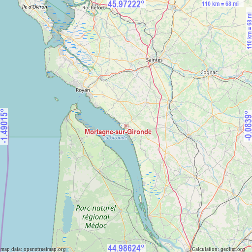
Mortagne-sur-Gironde GPS coordinates[2]
45° 28' 53.004" North, 0° 47' 13.272" West
| Map corner | latitude | longitude |
|---|---|---|
| Upper-left | 45.97222°, | -1.49015° |
| Center: | 45.48139°, | -0.78702° |
| Lower-right: | 44.98624°, | -0.0839° |
| Map W x H: | 109.6×109.6 km | = 68.1×68.1mi |
| max Lat: | 51.07786° ⇑74.3% North |
| Mortagne-sur-Gironde: | 45.48139° |
| min Lat: | ⇓25.7% South 41.3874° |
| min Long | Mortagne-sur-Gi | max Long |
| -5.08615° | -0.78702° | 9.52242° |
| W 13.7%⇐ | ⇒86.3% E |
Elevation
Elevation of Mortagne-sur-Gironde is 49 m = 161 ft, and this is 144.7 m = 475 ft below average elevation for this country.
| Max E: |
2333 m = 7654 ft | 82.2% |
| Avg. | 193.7 m = 635 ft | |
| Mortagne-sur-Gironde | 49 m = 161 ft | |
Min E: |
-1 m = -3 ft | 17.8% |
See also: France elevation on elevation.city.
Geographical zone
Mortagne-sur-Gironde is located in North temperate zone (between Tropic of Cancer and the Arctic Circle). Distance of this North polar circle is 2344.1 km =1456.6 mi to North.| Distance of | km | miles | from Mortagne-sur-Gironde |
|---|---|---|---|
| North Pole | 4950 | 3075.8 | to North |
| Arctic Circle | 2344.1 | 1456.6 | to North |
| Tropic Cancer | 2451.1 | 1523 | to South |
| Equator | 5057.1 | 3142.3 | to South |


Nearby cities:
15 places around Mortagne-sur-Gironde: (largest is in red/bold)
• Arces
9.8 km =6.1 mi,  320°
320°
• Bégadan
16.3 km =10.1 mi,  210°
210°
• Champagnolles
12.2 km =7.6 mi,  73°
73°
• Chenac-Saint-Seurin-d'Uzet
4.6 km =2.9 mi,  329°
329°
• Cozes
11.9 km =7.4 mi,  342°
342°
• Cravans
14.1 km =8.8 mi,  24°
24°
• Grézac
14.2 km =8.8 mi, 342°
• Gémozac
13 km =8.1 mi,  41°
41°
• Meschers-sur-Gironde
15.7 km =9.8 mi,  303°
303°
• Saint-André-de-Lidon
13.5 km =8.4 mi,  12°
12°
• Saint-Ciers-du-Taillon
13.2 km =8.2 mi,  119°
119°
• Saint-Dizant-du-Gua
8.5 km =5.3 mi,  129°
129°
• Saint-Fort-sur-Gironde
5.6 km =3.5 mi,  113°
113°
• Semussac
16.6 km =10.3 mi, 322°
• Épargnes
6.8 km =4.2 mi,  349°
349°
Sources, notices
• [Note1] Compared only with cities in France existing in our database
• [Src1] Map data: © OpenStreetMap contributors (CC-BY-SA)
• [Src2] Other city data from geonames.org with taken over terms of usage.
• [Src3] Geographical zone / Annual Mean Temperature by Robert A. Rohde @ Wikipedia
