Sainte-Jamme-sur-Sarthe geodata
Sainte-Jamme-sur-Sarthe (Pays de la Loire) is a populated place; located in France in Europe/Paris (GMT+2) time zone. With population of 1,742 people, there are 5433 cities with bigger population in this country. Compared to other cities in France, 61.9% of cities are located further ↓South; 76.5% of cities are located further →East and 79.4% of cities have higher elevation than Sainte-Jamme-sur-Sarthe. Note1
Administrative division(s):
- Level 1: Pays de la Loire
- Level 2: Sarthe
- Level 3: Arrondissement du Mans
- Level 4: Sainte-Jamme-sur-Sarthe
Current local time in Sainte-Jamme-sur-Sarthe:
03:31 PM, SaturdayDifference from your time zone: hours


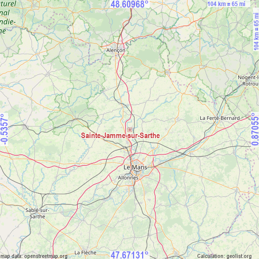
Sainte-Jamme-sur-Sarthe GPS coordinates[2]
48° 8' 33.504" North, 0° 10' 2.748" East
| Map corner | latitude | longitude |
|---|---|---|
| Upper-left | 48.60968°, | -0.5357° |
| Center: | 48.14264°, | 0.16743° |
| Lower-right: | 47.67131°, | 0.87055° |
| Map W x H: | 104.3×104.3 km | = 64.8×64.8mi |
| max Lat: | 51.07786° ⇑38.1% North |
| Sainte-Jamme-sur-Sarthe: | 48.14264° |
| min Lat: | ⇓61.9% South 41.3874° |
| min Long | Sainte-Jamme-su | max Long |
| -5.08615° | 0.16743° | 9.52242° |
| W 23.5%⇐ | ⇒76.5% E |
Elevation
Elevation of Sainte-Jamme-sur-Sarthe is 56 m = 184 ft, and this is 137.7 m = 452 ft below average elevation for this country.
| Max E: |
2333 m = 7654 ft | 79.4% |
| Avg. | 193.7 m = 635 ft | |
| Sainte-Jamme-sur-Sarthe | 56 m = 184 ft | |
Min E: |
-1 m = -3 ft | 20.6% |
See also: France elevation on elevation.city.
Geographical zone
Sainte-Jamme-sur-Sarthe is located in North temperate zone (between Tropic of Cancer and the Arctic Circle). Distance of this North polar circle is 2048.2 km =1272.7 mi to North.| Distance of | km | miles | from Sainte-Jamme-sur-Sarthe |
|---|---|---|---|
| North Pole | 4654.1 | 2891.9 | to North |
| Arctic Circle | 2048.2 | 1272.7 | to North |
| Tropic Cancer | 2747 | 1706.9 | to South |
| Equator | 5353 | 3326.2 | to South |


Nearby cities:
15 places around Sainte-Jamme-sur-Sarthe: (largest is in red/bold)
• Aigné
9.4 km =5.8 mi,  202°
202°
• Ballon
6.2 km =3.9 mi,  57°
57°
• Beaumont-sur-Sarthe
9.8 km =6.1 mi,  344°
344°
• La Bazoge
5.2 km =3.2 mi,  190°
190°
• La Guierche
3.6 km =2.2 mi,  147°
147°
• La Milesse
9.2 km =5.7 mi, 195°
• Lavardin
10.7 km =6.6 mi,  226°
226°
• Maresché
7.8 km =4.8 mi,  351°
351°
• Montbizot
1.5 km =0.9 mi, 56°
• Neuville-sur-Sarthe
7.6 km =4.7 mi,  165°
165°
• Saint-Mars-sous-Ballon
6.8 km =4.2 mi, 60°
• Saint-Saturnin
9.5 km =5.9 mi, 186°
• Sainte-Sabine-sur-Longève
5.4 km =3.4 mi,  267°
267°
• Souligné-sous-Ballon
5.1 km =3.2 mi,  96°
96°
• Vivoin
10.1 km =6.3 mi,  355°
355°
Sources, notices
• [Note1] Compared only with cities in France existing in our database
• [Src1] Map data: © OpenStreetMap contributors (CC-BY-SA)
• [Src2] Other city data from geonames.org with taken over terms of usage.
• [Src3] Geographical zone / Annual Mean Temperature by Robert A. Rohde @ Wikipedia
