Beaulieu-sous-Parthenay geodata
Beaulieu-sous-Parthenay (Nouvelle-Aquitaine) is a populated place; located in France in Europe/Paris (GMT+2) time zone. With population of 652 people, there are 12498 cities with bigger population in this country. Compared to other cities in France, 59.4% of cities are located further ↑North; 80.1% of cities are located further →East and 65% of cities have lower elevation than Beaulieu-sous-Parthenay. Note1
Administrative division(s):
- Level 1: Nouvelle-Aquitaine
- Level 2: Département des Deux-Sèvres
- Level 3: Arrondissement de Parthenay
- Level 4: Beaulieu-sous-Parthenay
Current local time in Beaulieu-sous-Parthenay:
12:33 PM, MondayDifference from your time zone: hours


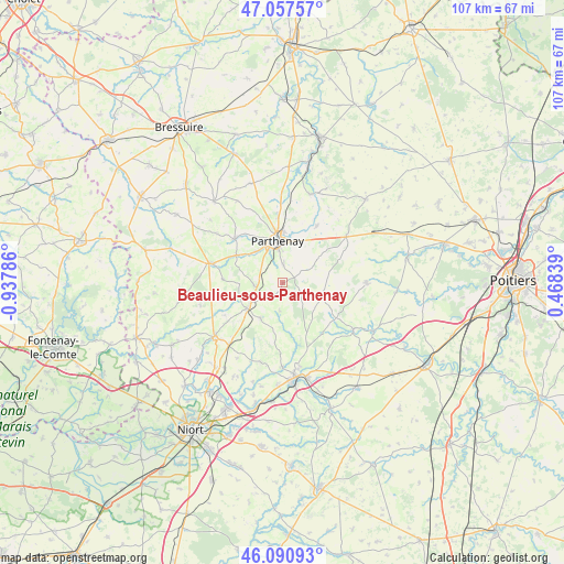
Beaulieu-sous-Parthenay GPS coordinates[2]
46° 34' 35.04" North, 0° 14' 5.028" West
| Map corner | latitude | longitude |
|---|---|---|
| Upper-left | 47.05757°, | -0.93786° |
| Center: | 46.5764°, | -0.23473° |
| Lower-right: | 46.09093°, | 0.46839° |
| Map W x H: | 107.5×107.5 km | = 66.8×66.8mi |
| max Lat: | 51.07786° ⇑59.4% North |
| Beaulieu-sous-Parthenay: | 46.5764° |
| min Lat: | ⇓40.6% South 41.3874° |
| min Long | Beaulieu-sous-P | max Long |
| -5.08615° | -0.23473° | 9.52242° |
| W 19.9%⇐ | ⇒80.1% E |
Elevation
Elevation of Beaulieu-sous-Parthenay is 194 m = 636 ft, and this is 0.30000000000001 m = 1 ft above average elevation for this country.
| Max E: |
2333 m = 7654 ft | 35% |
| Beaulieu-sous-Parthenay | 194 m 636 ft | |
| Avg. | 193.7 m = 635 ft | |
Min E: |
-1 m = -3 ft | 65% |
See also: France elevation on elevation.city.
Geographical zone
Beaulieu-sous-Parthenay is located in North temperate zone (between Tropic of Cancer and the Arctic Circle). Distance of this North polar circle is 2222.4 km =1380.9 mi to North.| Distance of | km | miles | from Beaulieu-sous-Parthenay |
|---|---|---|---|
| North Pole | 4828.3 | 3000.2 | to North |
| Arctic Circle | 2222.4 | 1380.9 | to North |
| Tropic Cancer | 2572.9 | 1598.7 | to South |
| Equator | 5178.8 | 3218 | to South |


Nearby cities:
15 places around Beaulieu-sous-Parthenay: (largest is in red/bold)
• Allonne
11.3 km =7 mi,  273°
273°
• Azay-sur-Thouet
10.4 km =6.5 mi,  301°
301°
• Châtillon-sur-Thouet
9.6 km =6 mi,  358°
358°
• La Ferrière-en-Parthenay
15 km =9.3 mi,  53°
53°
• La Peyratte
12.7 km =7.9 mi,  31°
31°
• Le Tallud
7.7 km =4.8 mi,  321°
321°
• Mazières-en-Gâtine
8.3 km =5.2 mi,  234°
234°
• Parthenay
8 km =5 mi,  353°
353°
• Pompaire
3.5 km =2.2 mi,  1°
1°
• Saint-Aubin-le-Cloud
12.4 km =7.7 mi,  312°
312°
• Saint-Georges-de-Noisné
9.4 km =5.8 mi,  190°
190°
• Saint-Pardoux
5.5 km =3.4 mi,  264°
264°
• Secondigny
14.4 km =8.9 mi,  284°
284°
• Verruyes
7.9 km =4.9 mi,  212°
212°
• Viennay
12.7 km =7.9 mi, 356°
Sources, notices
• [Note1] Compared only with cities in France existing in our database
• [Src1] Map data: © OpenStreetMap contributors (CC-BY-SA)
• [Src2] Other city data from geonames.org with taken over terms of usage.
• [Src3] Geographical zone / Annual Mean Temperature by Robert A. Rohde @ Wikipedia
